Category Archives: National Parks

Preparing for Isle Royale

In my previous post on ‘Planning for 2017’ I wrote briefly on going back to Isle Royale. I find this desire to backpack here very humorous because the last time I did this with the rest of my family I was adamant that backpacking was not for me and I would never do it again. I was glad to have experienced it once but that was enough. And now I can’t wait to return and hike further and for more days. What happened?

One of the shores of Isle Royal

Either I’ve gone crazy or have gained more knowledge on backpacking. First lets figure out why there was no desire to backpack again. Most of this came from hiking with a lot of extra weight on my back causing pain in my shoulders and back every time my pack was hoisted back onto my shoulders. The second reason is that sleeping was cold and uncomfortable leaving me tired much of the time longing for a good nights sleep. Other than that, I enjoyed the time on the island.

Getting up close to a moose can be very exciting if done safely for the animal and the viewer.

So what’s different now? A number of things have changed my opinion of backpacking bringing on an excitement to do it again. First is all of the information and experience I’ve gained since then increasing the confidence to be able to hike with extra weight and actually enjoy it. I now have a good idea of what is involved in preparing for an extended hike which includes hiking locally with a heavy backpack for a couple of miles each time along with biking a couple of days a week for several miles putting me in better shape. Also I have a nicer camera that I really enjoy using and Isle Royale is a great place for beautiful photographs adding to my excitement to be there.

A portion of the beautiful trails on Isle Royale

If I do this right the training backpack will be heavier than my actual pack making it seem like no big deal to carry all day long. Add to this increased muscle strength to be able to carry the weight while working around rocks and tree roots, using trekking poles to keep better balance and weight distribution, and bringing fewer items reducing my overall back pack weight should combine to make a fun hiking experience.

Sleeping in the solitude of Isle Royale can be difficult to get use to.

A few weeks after returning from Isle Royale the last time I began to go through our supplies and determined how I would pack differently another time to reduce the weight I was carrying. It was amazing how much different things felt for each pound we removed either in food or water weight making the pack lighter. We definitely brought too much food last time and heavy food at that. That is an easy place to reduce weight by several pounds. Also, sleeping gear last time was heavy lugging small air mattresses, cotton sheets, and blankets. This time a sleeping bag, light sleeping pad, and maybe a small pillow which should eliminate more weight. My only concern is increased weight in camera equipment so I will have to watch that part. As far as sleeping goes, I know there won’t be great sleep so I’m prepared for that so it should be less of a concern.

One of the Entrance Stations of Isle Royale

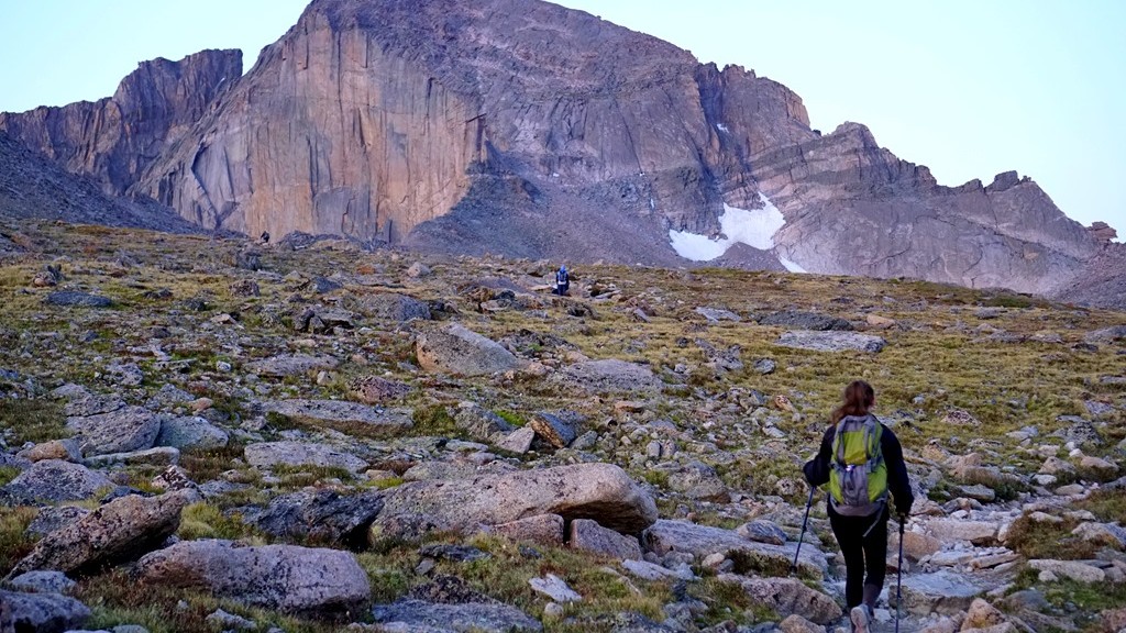
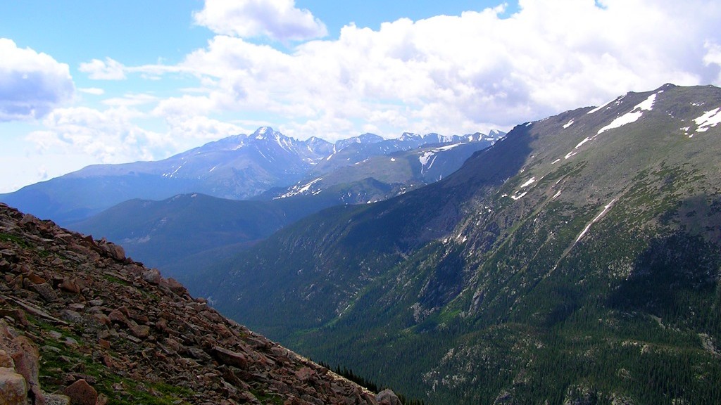
Training for hiking in the Rocky Mountains in 2016 and how successful it was and I was at completing a couple of 10 mile + hikes at higher elevations has proven to me that I can adequately train for this trip and go the distance with my backpack. In fact, at times I would even forget I was carrying my backpack loaded with clothing, food, and water all as a result of training before hand. The pack will be heavier this time as it will include more food, a tent, sleeping gear, and probably more clothing so I understand what I need to do to prepare. I’m so looking forward to this but there is much to do before then.

Climbing Longs–A Reflection

A good gage for me of if I liked an experience is would I do it again. Would I hike/climb Longs Peak again? It depends on when you asked me. For a couple of weeks following I would’ve told you I was glad I did it but probably would not do it again. Asking a couple of months later I would definitely consider doing it again if the opportunity arose in the next couple of years. Maybe that’s me just being stupid and forgetting how strenuous the hike is even before getting to the keyhole and how difficult the thinner air above 10,000 feet makes this hike. Being stupid or not I know now what to be prepared for.

The amazing sunrise alone was worth the hike to this point

For 2 days following the hike to Longs Peak I had difficulty walking because of pain in my legs. Getting up from sitting and sitting back down were functions I lacked without assistance. I credit this to going 6 miles downhill at a fast pace without taking breaks allowing my legs to gain adequate oxygen while trying to avoid the surrounding storms. The other piece that took away from the enjoyment of this hike was difficulty in breathing for much of it. It felt like I was always gasping for air whenever I wanted to climb after passing the Boulder Field Campground. It would not have been as demoralizing if there wasn’t a timeline due to storms and my ride at the trailhead pre-scheduled without a means of contacting my ride to re-schedule allowing for more enjoyment of a slower pace. I was unsure of my abilities in these conditions so I had to estimate a pick up time which turned out to be too early in the afternoon.

One of the beautiful waterfalls we passed in the night on our way up Longs Peak

While on the mountain trying to decide if we should continue on from the Trough or not I kept trying to determine if I would regret not summiting if that was the decision we made. Well, it’s been a couple of months now and I do not regret our decision. For the conditions it was the right call for us. It likely would have taken us an additional 2 hours to summit and make it back to our position above the Trough. We would have gotten caught in increasingly difficult conditions due to storms in our descent increasing the risk of injury or worse. I wish the conditions would have allowed us to continue to summit but that just was not our situation. There is such a great respect for those that take on this climb after having done almost all of it.

One of the many views from the top of the Trough

Upon completing this adventure I could not figure out how I felt about it. Was it worth all of the effort required to do it? I now feel a huge sense of accomplishment and satisfaction tackling Longs Peak. It was completely worth the work, pain, and dedication to climb this mountain. What an unbelievable experience and to have been able to share it with my oldest daughter is priceless. It would have been great to also share it with my youngest daughter but that would have been more than I could handle on my own given the risks involved above the Keyhole. The scenery was so beautiful and peaceful both on the way up in the serenity of a moon lit landscape and the way back down as the mountain tops turned white from the snow while we got rained on. It must have been a great accomplishment as I’m considering a hike to the top of Mauna Loa on our final Monopoly adventure to Hawaii Volcanoes National Park which surprisingly tops out at over 13,600 feet. Additionally I monitor the Longs Peak trail conditions and webcam having a more intimate relationship with this mountain now. I love adventures and this was an amazing one!

The Rocky Mountains from Longs Peak


Climbing Longs–Continue On or Not?

While taking in the views sitting in the Keyhole, Lysa and I discussed the next portion. Are we up for the next portion of this hike, which becomes a climb, and is considered more difficult than what we just completed. Our initial decision was to sit and enjoy our surroundings and return to the trailhead while the weather was in our favor as storms were predicted for the entire afternoon and clouds were beginning to form. You can see in the above picture of the next portion of our hike. There is a group following the trail towards a valley called the trough. Actually the trail looks fun except for one issue – being able to breath adequately at 13,000 feet. Going beyond the Keyhole the hike becomes increasingly more dangerous as a wrong step on parts of the trail can lead to serious injury and even death as has happened here before.

Sitting and enjoying the awesome surroundings while watching others maneuvering the trail was nice but a feeling kept burrowing deeper inside us. What’s it like on this trail and what’s around the corner that we can’t see? Well there really is only one way to find out! On went the packs as we moved to boulders making up the trail which is marked by red and yellow bulls eyes. The morning sun was warming us at the Keyhole but as we began this portion it was in the shadows with colder temperatures. Thankfully we had gloves as the boulders are quite cold up here. The trail wasn’t too difficult as long as you take your time and watch your step while grabbing boulders to maintain balance and support among this unforgiving granite.

Making our way to the Trough in the background

Time flew by as we slowly made our way up and over numerous rocks towards the valley called the Trough. There are a few challenging boulders to climb over but for the most part it was a nice climb/hike. Reaching the trough fatigue was beginning to set in.  This is concerning because it can lead to poor decision making in a place intolerable to it. Even though we took a few breaks along the way we needed to stop for a longer period of time to regain our oxygen levels and leg strength before the next section which requires continually climbing up.

Clouds continued to build around the mountains causing us to try and push towards the top so we began climbing the Trough as quickly as possible. About a third of the way up we began to get light headed and dizzy at times along with trembling legs. At this point we knew we had to slow down and take more breaks in order to get enough oxygen to continue our climb. After this point we would climb about 10 or 15 feet up and take a short break. That seemed to help maintain our strength but slowed down our climb. While we were climbing up there were others working their way down sliding from time to time making us realize up may actually be safer than coming back down. Occasionally a rock would come flying down towards us from other hikers above requiring us to take cover from time to time until the rock passed without incident. Eventually we picked our way through the rocks getting close to the top of the Trough reaching, what at first glance, was an impassible boulder. Taking some time to study our options we chose a path and nervously worked our way up and over this boulder and arrived what felt like on top of the world. There’s a geological marker here stating that we had made it to 13, 749 feet. Only 500 feet left to the top of Longs.

Climbing the Trough

We sat on a narrow strip of granite taking in our surroundings and resting after this energy draining climb up the Trough in preparation for the next section. Again the discussion arose of continuing towards the summit or not. After a few minutes we came to the conclusion it was time to call it a day and turn around. There were multiple reasons for this. First, clouds were continuing to get darker and there were obvious rain showers in the distance working towards us. Next, we had someone picking us up from the trailhead at a designated time and looking at the current time we were already going to be pushing that time. Finally we were very fatigued and still needed to climb down these difficult sections safely. I estimated we would need another 2 hours in order to make it to the summit and begin our descent which I was not interested in doing in thunderstorms with wet, slippery rock. Especially with my daughter.

The view from the top of the Trough

After taking some additional time enjoying the view, eating and drinking to replenish, and resting to re-gain strength, and talk with other hikers about the situation we began the climb down scrambling around this almost impossible boulder while others tried to figure out their way around it climbing up. With their assistance we made it down safely over this boulder and continued down the Trough making our way to the Keyhole once again. It felt good to be back to this point safely before any rain started to fall. Taking the last few minutes at this altitude we surveyed the area as it’s so incredible knowing we will not likely be back here again in our lifetime.

Taking in the views

Shortly we made our way down to the Boulder Field campground feeling good about what we accomplished and that it’s all down hill on relatively easy trails from here just as thunder began rumbling off in the distance. Better get moving in an attempt to reach the tree line before storms reach us. We didn’t make it far before thunder began to boom overhead bringing with it a rain/snow mix which we hiked in for the next couple of hours. Fortunately there wasn’t visible lightning striking the mountains allowing us to continue our hike instead of seeking out a depression along the trail to take cover in. Yes, the decision to forgo reaching the summit now seemed like a good call as we would have been caught somewhere above the keyhole on wet boulders or possibly snow as the mountain peaks around us were turning white making the hike even more dangerous and time consuming. The rain passed as we reached the tree line with only a few more miles to go before meeting our ride and the end of this adventure filled and tiring day.

Approaching rain/snow and storms

The return brought us down over 6 miles almost without stopping in an attempt to reach safety with storms expected much of the afternoon and then to reach the car. Because of this our legs became increasingly more sore with each step down we had to take. If we would have taken a few breaks to rest we would have been in good shape having accomplished an amazing hike.


Climbing Longs–The Keyhole

Now at the Boulder Field Campsite we were able to take in some of the surroundings, enjoy a little camaraderie with other hikers attempting to do the same thing, and use toilets in preparation for the next portion of our morning hike. (To catch up with our journey thus far click here to read the previous story.) It was noticeable how much colder the air was here. Even though we were almost the same elevation as the top of Flattop Mountain it seemed much colder to the point of being able to see our breath from time to time. Fortunately the sun was quickly warming us up. While studying the boulder field it became obvious that these boulders filled in the keyhole and more at one time. What natural event occurred causing this part of the mountain to crumble forcing all these large pieces of rock to fall making a river of boulders and leaving this keyhole? Was it ice, an earthquake, or something else?

Looking up at the boulders to be climbed to reach the Keyhole

As I scanned around I kept wondering how can the remaining portion of this hike to the summit be all that difficult? It didn’t appear to be all that long distance wise or a great elevation change from the boulder field. Of course elevation is a major factor for those of us not use to it. After 15 minutes or so we decided to continue on towards the Keyhole. There were several other hikers that climbed up ahead of us providing information on the climb we were about to do. Watching from a little distance it appeared they were going up fairly slow and taking their time. I’ve climbed over rocks before and it doesn’t take that long to continue upward.

A marmot coming to be pet with a hiker in the background climbing boulders

We decided to pack our trekking poles away as they weren’t likely to be much help on the boulder terrain and lifted the packs back onto our backs ready to continue. For this section of the hike on Longs you are basically boulder hopping. Stepping towards the next boulder hoping it’s stable while making your way increasingly higher. At least that’s the plan as it’s easy to just stay at your current altitude and just go sideways if not paying attention. Quickly you begin to realize the altitude makes things increasingly difficult simply because the thinner air causes problems getting enough oxygen to breath normally. It feels like you are running and out of breath after a short time slowing down the pace. Now it makes sense why the hikers ahead of us appeared to go so slowly up into the keyhole. In addition, the higher you go the larger the boulders get and the steeper the incline gets. Looking at the photo above you see a marmot that seemed to want to get pet. In the background is a good comparison of the boulder size next to a hiker.

Exploring the vaille

Getting closer to the keyhole we reached the Agnes Wolcott Vaille built as a place of protection from storms for those attempting to reach the top of Longs Peak. Finally almost there! A few minutes exploring this shelter and it was to the keyhole to view out over the Rocky Mountains. We’ve reached the main goal of this adventure – the Keyhole!

One of the views from the other side of the keyhole

Many hikers ahead of us proclaimed the amazing views while perched among the slim layer of rocks forming this keyhole continuing to encourage those below to reach it. They were right about the incredible views sitting in this unique rock formation. From both sides of the keyhole the landscape humbled us with its beauty and vastness. We felt so small among these huge boulders forming large mountains. It seemed to take forever to climb from the campground into the keyhole but according to the timestamps on the photos taken it only took us about 20 minutes or so to complete. While sitting in the keyhole eating a Clifbar and drinking more water we examined the next portion of trail that would take us to the summit of Longs Peak if we felt up to the challenge. I think the expression on Lysa’s face in the picture below gives a good idea of our thoughts!

Sitting in the Keyhole studying the next portion of the trail


Climbing Longs–Getting There

Our journey towards Longs Peak began at 2:30 am. That’s 2:30 am at the trailhead! We were not the first ones there at this time of day as this is a relatively busy trail in the summer but you must start early because it is a long and challenging trail with rain/snow/thunderstorms possible during the afternoon. We began the trail half asleep and unsure of what lay ahead but there were several others here in the same situation so up we we go. Surprisingly it was quite warm at almost 60 degrees F at the start of the trail. I was expecting temperatures in the 40’s during this time of night so off came the jacket before even starting as 60 degrees F is very warm for this strenuous of hiking.

Getting ready to hike to Longs

The entire trail to the summit of Longs Peak using the Keyhole Route is about 7.5 miles long each way with most of that trail needed just to get to the Keyhole. This takes you from the trailhead, up through the trees before reaching the alpine environment above the tree line, and around Mount Lady Washington. Hiking this distance on easier terrain is not terribly difficult for me and I’ve been preparing for this for several months, as you can read here, however this is continually hiking up, often time over steps, rocks, and tree roots, at a fairly steep incline. Even at that, the hiking was not as challenging as I expected which was a nice surprise. The difficulty came with the altitude. Above 10,000 feet, breathing becomes more difficult for me slowing down the pace in order to get adequate oxygen to continue on.

Longs_Peak_map

As we reached the tree line and began hiking in the tundra we got our first view of Longs Peak from closer up. It was a beautiful moonlit morning with the full moon hovering just above the mountain giving us a perfect outline of where we were headed.

Hopefully this is making sense because there are thunderstorms with a lot of lightning as I’m writing this causing distractions.

We took a few minutes to rest and enjoy the surroundings. It was fun to see all of the little lights bobbing along the trail both ahead of us and behind us. Like a little hiker road. While taking this photo the camera low battery symbol began to flash and I realized I forgot extra batteries for this camera and didn’t charge the batteries for the GoPro so taking a lot of pictures was out. This bummed me out because when am I likely to be here doing this again? After coming to terms with my lack of picture taking ability we moved on around Mount Lady Washington.

The first view of Longs Peak with a full moon just above

Almost around Mount Lady Washington and to the boulder field, the sun began to cress the horizon giving us an amazing sunrise way up on the mountain. A sight I hoped to see since preparing for this hike. It took my breath away! Maybe that was just the altitude while hiking. At this point people had created a relatively smooth trail placing stones together to create a sort of sidewalk making it more of a walk than a hike for a little distance. What a nice reprieve from steps and stones! Thank you to whomever did this.

With the sun rising we got our first good look at the mountain we were aiming to climb which is the main photo above. Surprisingly it didn’t look as insurmountable from here as it did from Flattop Mountain and other areas around Rocky Mountain National Park. We’ll see if that stays the case once we get there. Off towards the right I could see the Keyhole which has been the first goal of this hike. Anything after that would be a bonus. A short time later we arrived at the Boulder Field Campground and took a much needed rest before climbing up into the Keyhole. Yes, there really is a campground up here.

It took us about 5 hours to reach the campground and we traveled about 6 miles to this point. Feeling the strenuous hike it felt nice to sit for a little while and take in the views while mentally preparing for the next part. In my research it was said that this is the easy part of climbing Longs Peak. It didn’t seem all that easy to me! What are we in for next? To be continued…..

Sunrise on the mountain


Exploring Flattop Mountain

Back in 2009 we visited Rocky Mountain National Park to hike to Flattop Mountain Trail and we did that successfully. Unfortunately that was done after a long day of exploring so there wasn’t much energy to continue further. I’ve wanted to attempt the trail again if the opportunity presented itself. Well, recently we made the opportunity happen and once again found ourselves on the trail. Surprisingly the beginning of the trail looks very different from what it looked like seven years ago as proven in the next two photos.

Flattop Trail in 2009

Flattop Trail in 2016

The top picture was taken in 2009 and the next one taken just a few weeks ago. I can find now similarities to them which made it a little challenging to begin this hike since there wasn’t really recognition of the beginning of the trail causing me to question if we were on the right path or not. Especially since it was still dark when we got to this point. Trusting in the trail signs we pressed onward towards the top.

Flattop Trail Head when we began our hike from Bear Lake

Our hike on Flattop Mountain began at 4:30am as we passed Bear Lake. The scene is pictured above. In the dark, armed with flashlights, our journey on this mountain trail began to climb towards to top. In a short time we began to see light on the horizon however the trail swallowed by trees continued to be dark requiring artificial light sources to make our way over rocks and tree roots as we went up, up, up, to the sky.

Sunrise from the mountain

As we continued on this trail we could begin to feel the effects of the ever thinning air making it more difficult to breath and hike at a fast pace. Increasing our breaks while we trekked higher the trees began to decrease in size indicating the approaching tree line where they can no longer grow in the cool mountain air. Daylight finally penetrated this forest trail just as we broke above the trees bringing spectacular views of the mountains surrounding us with Emerald lake in the valley below. Our climb began below this lake and now look how high above it we are. Progress.

Overlooking Emerald Lake

Marmots appeared from the rocks in the mountain to greet us as we passed their homes. They made for a more interesting hike once reaching the tundra of the alpine zone on Flattop Mountain. Watching as they climbed in and out of boulders and finally on top of them to grab the warmth of the morning sun before gathering food for the day was extremely entertaining.

Marmots came out to greet us

They would definitely not be outdone by their smaller tundra mates – the Picas. These smaller alpine mammals would give a sharp squeak but would not always come into view as they moved between the rocks and boulders. If you watched long enough there would be a glimpse of movement and out would come one of these soft Picas running across the surface as they gathered portions of plants to store in their nests giving another squeak as if to say good morning while we passed.

Picas roaming around on the tundra

After several hours of hiking and a number of breaks to catch our breath we reached the summit of Flattop Mountain. I always imagine mountains as these immovable pieces of solid stone reaching towards to sky. It surprises me as we walk the top of the mountain that the top is scattered stones and boulders showing they are not as solid as originally perceived. The elements continue to work on these mountains breaking them apart slowly over time. For now it’s a great challenge to climb to the top of these massive rock formations.

Reaching the top of Flattop Mountain

In our picture above you see Hallet Peak to the right which is the next mountain over and one we briefly discussed climbing but decided this was enough for today as the real  challenge rests in the left of this photo – Longs Peak. A hike for another day. With our goal achieved for today we spent some time exploring and taking in the sights of our amazing surroundings, and watching some of the animals as they went about their business for the day.

One of the vast views from up here

After a little rest and energizing food we ventured to the nearby Continental Divide Trail. I’ve read about people hiking this entire trail covering over 3,000 miles from Mexico to Canada and wanted to walk a little of this beautiful trail. There were large cairns marking the trail most likely to show where it is during the spring and fall when snow could cover it making a more challenging hike and increased likelihood of getting lost. Further exploration on the CDT was tempting but it was time to head back down the mountain. With our destination successfully found we began the descent back to Bear Lake.

Exploring the Continental Divide Trail


Preparing for a Rocky Mountain Hike

Since exploring Rocky Mountain National Park in 2009 I’ve wanted to return as it is such a beautiful place. Our last trip was to hike to Flattop Mountain Trail which is the location on our National Parks Monopoly Board. In 2009 we made it to the sign and returned to the car. I’ve always felt that I would like to hike the trail in its entirety someday.

Flattop Mountain Trail

That someday will happen this summer. Or at least we are going to be back in the park and hopefully the weather cooperates allowing me to hike to the top of Flattop Mountain which is a 10 mile hike round trip. Typically 10 miles isn’t a concern for me but it gets a little more difficult with the incline/decline and altitude in a mountain setting. Flattop peaks at just over 12,000 feet altitude and while this has an impact on me it wasn’t very bad the last time I was at this height.

Look at the beautiful surroundings

In addition to Flattop Mountain I’ve added in the challenge of hiking to the top of Long’s Peak which is a 15 mile trip and tops out just over 14,000 feet in altitude. A few years ago I would have never considered doing this as I’m not in physical condition to do so. After reading a few long distance hiker’s blog I began to consider it and figure out what it would take for me to do.  The idea of hiking to the top of the tallest peak in Rocky Mountain National Park, which I’ve looked at from an airplane, and see it from the other direction is a challenge I want to take on.

In order to be successful at these hikes I’ve been in training since January to build my legs and also try and increase my lung capacity as much as possible to prepare for the thinner air at higher altitudes. This training has included hiking several miles at a time carrying a 45 pound training pack which is at least double the weight of what my actual backpack will be. Hopefully the actual pack will feel quite a bit lighter so I don’t mind carrying it for a much longer distance. The training pack also put a heavier load on my legs building those muscles a bit more.

One of my practice hiking trails

Additionally I’ve been working with inline skates and biking with the occasional walking up and down stairs for 45 – 60 minutes with a loaded backpack on. Some days have been more challenging than other to go work out just like it is for anybody. In January I would go out on the trail even at temperatures of –12 degrees F and in the summer heat and humidity when I would return home so full of sweat I looked as though I had jumped into a lake. During these time I just needed to think about climbing mountain trails and my motivation would quickly return and I could walk faster or pedal harder forgetting about the conditions I was training in.

Biking on the trail

The time has come to see if all of that training will pay off in the form of an easier and successful hike. Certainly some of the mountain trails, especially near the top of Long’s Peak, have been a little intimidating but I’ve seen enough video and photos of the trail and have enough confidence in my abilities that as long as the weather remains favorable I’ll make it to the top.  If the weather does not cooperate than the risk does not become worth the reward of summiting Long’s Peak and I will turn around which is why the planned start time is around 2:30am to increase the odds of completing my goals. It’ll be fun either way I’m sure as there is nothing but amazing scenery all around.


Hot Springs

Hot Springs National Park was a little surprising to me. I know that there are hot springs there and heard a little about bath house row but expected that much of the park consisted of natural areas with hiking trails through it. Usually there are entrances to the park with signs near the boundaries indicating your arrival.

Spring flowers blooming in abundance

In Hot Springs you drive into town and come upon bath house row which includes the visitor’s center and park sign.  As we drove towards this park following our GPS navigation system it announced we had arrived. I looked up and there was bath house row immediately in front of us. Where were the hiking trails? As we continued to explore this National Park we found a scenic drive with overlooks, that we’ve become accustom to, since these bath houses were closed for the day.

Looking out over Hot Springs

During our exploration we discovered a couple of hot springs running out of the ground. It was surprising how hot the water is trickling from these springs as they steam in the cooling evening air. Even though we knew the water was warm we were unprepared for how warm – hot the water is.  It averages 143 degrees Fahrenheit which is warmer than I thought it would be. A nice, unexpected treat as we wondered through the National Park on our first evening in the area.

Two of the hot springs emerging from the ground

The next morning we returned to bath house row just before they began opening for the day and wandered around looking at all these magnificent buildings built to provide hot, soothing baths before hot baths were commonplace. To be honest, when I first heard of bath house row I imagined more of a brothel type situation but learned that these bath houses where for relaxation and healing which was confirmed by the acknowledgement of the US Park Service maintaining this area. They probably wouldn’t do that if they were in fact brothels. My perception of the bath houses of Hot Springs was changed.

Looking down Bath House Row

Once these buildings began opening we entered the Fordyce Bath House which is now the park visitor’s center and used to explain how bath houses operated and the services they provided. We began by learning about bath house row and some of the history of the bath houses lined up next to each other. Then we moved on to a changing and waiting area for use of the showers and bathtubs.

Waiting and Shower lounge

While walking around exploring the Fordyce Bath House we were able to see some of the showers and tubs people would pay to use for the hot water flowing from their faucets to soothe their aching muscles and sore joints. These were the first “hot tubs” and provided the basis for using hot water to relax and recover in.

One of the bath tubs used to soak in the natural warm water

It is interesting to see how many pipes and shut off handles were used in these bath house showers.  Probably the basis for today’s more extravagant showers. It’s difficult for me to imagine what baths and showers would have been like without hot water heaters. Not very pleasant I would guess especially in the winter months.

Hot Springs shower

Other people would opt for a steam bath so they would climb into these steam boxes where they would sit and have steam from these hot springs pumped into the boxes helping to heal sore muscles and joints. Any piece of these hot springs were considered beneficial and having healing properties. Today these types of therapy are in most house holds all thanks to water heaters.

Steam chambers

Once their time in hot showers, warm baths, or steam chambers was complete they would take time to just sit and relax enjoying their reprieve from aches and pains. There were spaces created for doing just that with comfortable seating, soothing music playing, pool tables, fireplaces, or places in the warming sun to sit.  For many people, these life recharging waters would be an all day event. Athletes began to visit these houses to help their recovery speed up because of the healing benefits of Hot Springs.

One of the areas to relax after a hot springs bath or shower

The U. S. National Anthem

Every time I hear the United States National Anthem, there is a deeper meaning after visiting the place it was written – Fort McHenry in Baltimore, Maryland. One of the first things you can see upon nearing the fort is the tall flagpole carrying a huge American flag which author Francis Scott Keys was looking for during the bombing of the fort by British soldiers.

Canons protecting the fort

Once inside the fort, you can see where the canons that defended this fort during the attack were placed. This brings the attack to life imagining soldiers maneuvering cannons and loading them to fire back at British ships in Chesapeake Bay outside of the fort while taking cover as these ships fired back.

Looking out into Chesapeak Bay where the National Anthem was first written

Walking along the top of the fort walls, Chesapeake Bay is clearly visible shining in the bright blue, sunlit sky. After seeing the fort and many of its canons you begin to visualize British ships in the water firing almost causing you to quickly duck back behind the brick walls for protections.

Watching the flag flying in the wind high over Fort McHenry

It’s very humbling to think of this large icon of America, its flag, flying in the wind while soldiers engaged in heavy battle firing at each other through a smoke filled sky created from canon fire. To imagine what this must have looked like to Francis Scott Keys and the impact it had on him during these days. His surprise, joy, and pride to see Fort McHenry and the United States flag continuing to exist in all their glory once the battle ceased. On this Independence Day I have further respect for those who have given much to give us our freedom and continue to defend it yet today!

A huge American flag flying in the courtyard


Petroglyph

Excited to begin our Spring Break adventures, we landed in Albuquerque, New Mexico on a warm spring like day in mid March headed to Petroglyph National Monument. This National Park is a smaller park in Albuquerque established to preserve the rock drawings created hundreds of years ago. This was our second Monopoly board excursion with much to see and learn.

Walking through Petroglyph National Monuments enjoying the snow capped mountains behind

Petroglyph has a number of short hiking trails which bring you near many of the drawings carved into volcanic rock by people living in this area long, long ago and a modest visitors center to provide more information of this area and its formation. We took in a few of these hikes while enjoying the warmth on this bright, sunny afternoon with mountains lining the horizon. A great day to be here, especially since when I returned a week later it was to snow and ice blanketing many parts of this area.

Studying on of the petroglyphs

Most of the hikes wonder around and through rocks and what must younger people do when approaching rocks? Well they must be climbed of course. Before allowing them to touch a rock we tried to find any petroglyphs so they would risk damage even though these rock drawings have been there for hundreds of years and likely have been climbed over numerous times before.

If there are rocks around, they must be climbed

While hiking we would come upon a petroglyph which was interesting but it seemed like a bunch of kids were let loose in the park with sticks or rocks and told to draw on the rocks. How did we know if the drawings were 5 days old or 500 years? It was hard to know in most cases so we had to just believe these have been there for a long time. We were amazed at how well preserved they were given how long many have been here although I’m very poor at analyzing them to figure out what they may be showing so well preserved or not, I couldn’t really decide what they were portraying. Most of the petroglyphs were simple shapes to depict and animal, bird, or person with some being more intricate to show a particular type of person or event. Seeing these rock drawings in person provided some great historical education to think back on when traveling to different places.