Tag Archives: exploring

Meandering Through the Smoky Mountains on a Horse

Exploring a National Park by driving and hiking through it is the most common, riding a horse was something different for us and what better place to do that than Great Smoky Mountains National Park? There are a couple of horse stables in this park. The one we chose was Cades Cove Riding Stables because that was the one closest to where we wanted to explore that day.

The Rhododendrons were just starting to bloom

Our ride lasted for about an 45 minutes through beautiful forests of the Smoky Mountains so it was long enough to enjoy it but not too long where those of us not use to horses would get sore. The day began cloud covered with the threat of rain but we managed to stay dry and see peaks of sun as the ride continued making for a great summer morning while taking in these surroundings. Several of the Rhododendrons were just beginning to bloom along the trail providing for an even prettier landscape to ride through.

Beautiful scenery on a beautiful summer morning in the Smoky Mountains

The trail leader was very knowledgeable about the horses and trails and took care of any potential issues with the horses quickly. Some horses just don’t perform as well next to certain other horses so sometimes it’s best to keep them separated in a group. Once in awhile a horse wants to go at a different pace than the rest of the group and needs to be put back in their spot to follow the group for the best and safest ride for all. If your in Great Smoky Mountain National Park and are interested in spending time on horses, I definitely recommend Cades Cove Stables. And NO, I was not compensated to say that.

Riding through one of the numerous streams

The Frozen River

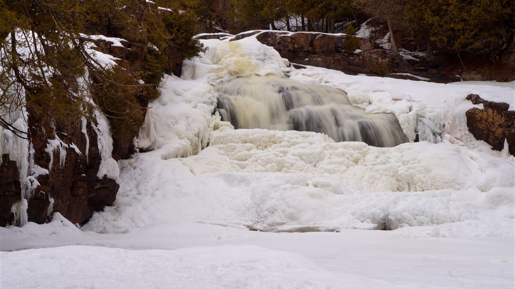
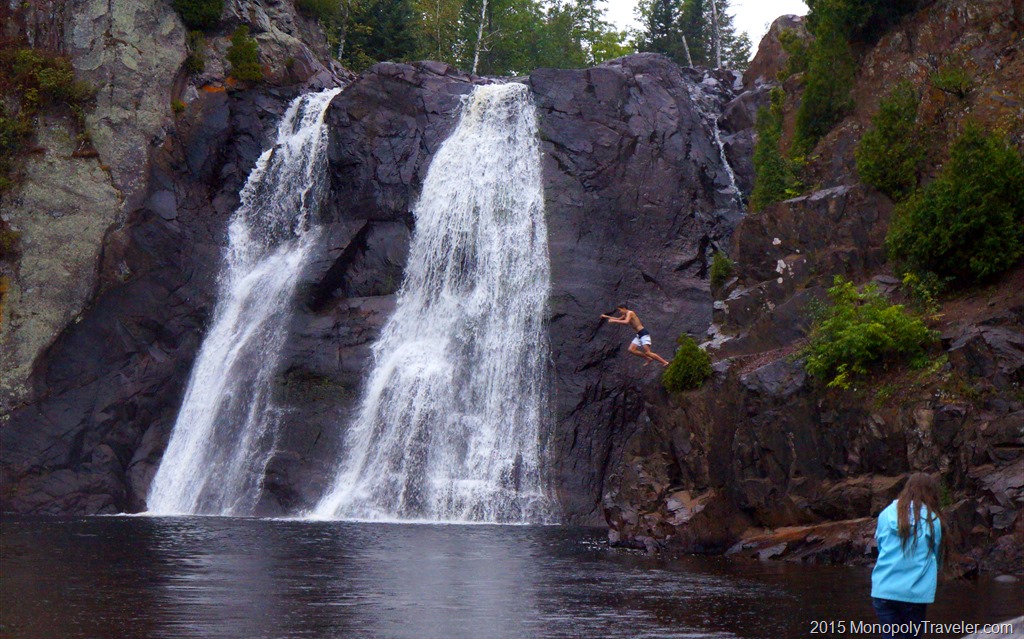
After a day snowmobiling through Northern Wisconsin we (my cousin and I) wanted to take in a waterfall or two coated in fresh snow so off to Gooseberry Falls we drove. That was the last weekend of the season the trails were open for snowmobiling as it worked out. How fortunate for us?! I was expecting the river to be flowing freely surrounded by fresh snow for some very picturesque landscapes. To my surprise the ice was still well intact over much of the river and waterfalls. For a comparison I’ve included a photo of these same waterfalls during the summer.

Surrounded by Ice

I’ve never been to this area during the winter to see what the waterfalls look like iced over so this was interesting to explore in a completely different perspective. Seeing the waterfalls frozen made me wonder what the process looks like during the winter as the ice gets thicker and thicker. I was also surprised how many people were visiting the falls and taking in a beautiful winter day exploring this state park.

Gooseberry Falls in the summer

Most of the visitors were hiking around the falls, which is what we were doing while some were there to photograph the ice covered waterfalls and one individual was climbing up and over the frozen portions of the falls. Taking some time to talk with him, he says this is his winter version of rock climbing, an activity keeping him out and about enjoying life. It was fun to watch as he picked through the ice with axes and cleats.

Climbing the ice walls

While hiking through the state park I discovered trails in locations I wasn’t aware of trails before. I’ve been to this state park a number of times and never discovered a trail on the opposite side of these waterfalls on top of the cliff overlooking this gorgeous landscape. The views from this newly discovered trail are well worth the extra distance required to get to them. That’s were many of these pictures were taken from. You can see the different angles between most of the waterfall photos and the summer shot.

Peering inside the layers of ice covering the river.

Because one of my goals for 2016 was to photograph snowflakes, I’ve started to look more closely at some of the details in the ice and snow this year. Especially melting ice and snow. The picture above shows the layers that make up ice covering the river as portions are beginning to melt. Some of the freshly fallen snow was beginning to melt and gliding down the ice creating interesting trickles across the several inches of ice still coating the river.

More layers of melting ice.

As we continued our hike around a portion of the Gooseberry River I found a few other locations providing a snapshot into the layer upon frozen layer of water making up this thick sheet of ice. In the above photograph you can see the layers underneath the top layer which is still coated in snow. The darkest portions are running water flowing underneath all of this ice. I believe the water depth in this area is several feet so while it looks relatively shallow, that look is deceiving.

Waterfalls frozen in place

Making our way to the lower falls you can see the magnificent rocks covered in all of this ice. in our explorations we confirmed water running under much of this as there were a few spots open to the water underneath as well as sounds of rushing water muffled by layers of ice. There were some great shapes created from the freezing and thawing during the recent days. It’s interesting to look at all these little details that combine together to make this amazing ice walls. Sometimes I forgot I was standing over running water as I was attempting to photograph these small icicles and crystals and their curious shapes.

One of the many icicles making up this huge ice wall.

Darkness was approaching on this already cloud covered light and the wind was growing colder so it was time to exit this beautiful ice river and falls. Before we did I was amazed further by the resilience of trees that grow out of these rock ledges as in the winter they are also ice covered. How they continue to grow surprises me and I work with plants almost every day. These tree roots and icicles clinging to the side of this stone wall made for a sight you don’t expect to see.

Tree roots growing through ice and rock

Gooseberry Falls State Park has a beautiful visitors center with great information about the North Shore of Minnesota but was unfortunately closed as we were exiting. In the absence of park personnel, we were sent on our way by some of the park residents. Although they seemed to prefer our departure instead of wanting to be interacted with.

Local resident deer sending us on our way

Agate Fossil Beds

Agate Fossil Beds National Monument one of the smallest national parks we’ve visited but an interesting place to explore with some surprising things to learn. Before finding this place because of the Monopoly board I had no idea that fossils have been found in this part of the Midwestern United States. Once again another pleasant surprise from our Monopoly adventures.

Some of the mammals fossils

This park requires only a few hours to explore but has much to offer for it’s size with information on the significance of the area for the Sioux as well as fossils to view both in the visitors center and along trails. In addition there are great views of the plains that make up large expanses of the landscape in western Nebraska.

Looking out at the vast prairie

One of the unique fossils which has been preserved in this national park are corkscrews dug deep into the earth by a type of land beaver that use to reside in these hills. When you see them you can’t help but wonder why they dug these burrows in the shape of a corkscrew. I question if it was to help them get in and out of their underground home. Maybe they couldn’t climb in and out of these deep holes any other way. Still, these corkscrews called, daemonelix or devil’s corkscrews, added a lot of steps each time entering and exiting these dens. A workout just to get up and go outside and retreat back into shelter. Probably worse than stairs in our houses.

There are fossils hiding in these hills

Waterfalls at Tettegouche

High Falls on the Baptism River

While hosting a student from France this summer we took a couple of days to head to the North Shore of Minnesota to see Lake Superior. A great place to stop is Tettegouche State Park to see both Lake Superior and the highest waterfalls entirely in Minnesota (there’s one slightly taller but it borders Minnesota and Canada). This was in the middle of August so the waterfalls are not gushing with as much ferociousness as earlier in the year but still a beautiful sight. It was raining and nearing nightfall during our time here which actually allowed us to have these falls all to ourselves. A rare opportunity this time of year.

Jumping into the Baptism River at High Falls

The Baptism River is cold (yet warm when compared to Lake Superior) people like to swim near the falls and jump from a nearby cliff. A dry towel to wipe the water from your skin and warm clothing to put on shortly after was a good idea on this day as the temperature was not very warm and there was no sun to warm up in so hypothermia was certainly a possibility. If you’re ever in the area I highly recommend a stop at Tettegouche State Park to explore the high falls. There is a short hike of just under a mile to get there from the nearest parking lot which is worth it if you can make it. There are a couple of smaller waterfalls to see if you have the time to hike to them. Darkness was approaching so we were unable to check out the rest of the smaller waterfalls. That will have to wait for another time.

Up the River to The High Falls

The Place of a Thousand Drips

Waterfall Stream at the Place of a Thousand Drips

On our last morning exploring Great Smoky Mountain National Park we decided to find one last waterfall or two that are listed as waterfalls that you can drive to on our Waterfalls pamphlet we purchased the day before at the Cades Cove Visitor Center. This is a stop on the Roaring Fork Motor Nature Trail which is basically a hiking trail for cars for those unable or unwilling to hike. There are several places to stop on this trail and hike if you desire otherwise there’s much to see from the comfort of your vehicle. I don’t recommend bringing a large RV through this area as the roads are one land with several tight corners.

_DSC0093

There is a pull off on the right side of the road which you have to cross to see this tiny waterfall. At least it was a tiny waterfall while we were there. Looking at other peoples pictures of this place show much more water flowing during wetter times. In order to see the waterfall up close we had to scramble up a few steep rocks which is just the sort of challenge made for a younger person and so up we went. Once near the falls you could see many areas where water was dripping through the moss making its way eventually to a small stream in on to one of the many rivers in the park. It was easy to determine that we were there during a dry time as the moss which clings to the sides of rocks was beginning to dry down in the summer sun. During the wetter times this climb may be too dangerous to do because of the slippery rocks so a definite advantage of the lower water flow.

Viewing the Falls From a Nearby Small Cave

Early Spring in the Woods

The First Flowers of the Spring

We had a few absolutely beautiful spring days with temperatures in the upper 60’s to lower 70’s and I couldn’t stay inside and take care of the many things needing attention. I had to escape to the outdoors and go exploring. The first flowers of the spring were just beginning to open up providing a comfort in knowing that winter has lost its grip once again and it is time for our landscapes to come alive. In searching for these early signs of life I learned that the flowers that bloom before the trees leaf out are called ephemeral flowers. Time well spent avoiding the to-do lists as these types of days are limited each year and must be taken advantage of if at all possible. The photo above is of bloodroot growing under the protection of a massive oak tree. Below is moss which has the old spores from last season along with new spores for the current season. The last photo is of a rue anemone. All of these flowers opened up while I was exploring the woods they were found in making it fun to witness.

Moss Actively Growing


More Ephemeral Flowers

Exploring Louisville Kentucky

Louisville Kentucky

At first thought, Louisville Kentucky is not in a lot of peoples list of places to go. That is except for one day a year – The Kentucky Derby! We took a weeklong trip recently and once we started looking at what there is to do, we found plenty to keep us busy. The number one attraction on TripAdvisor is the Mega Cavern. This was certainly on our list but we never did make it. If you’re looking for a unique adventure, this would appear to be it with underground ziplines and ropes course. For sports enthusiasts there is the Louisville Slugger Museum and factory. That was something I forgot about until getting to Louisville and seeing signs with the bat on it.

Walking Bridge Over the Ohio River Connecting Kentucky and Indiana

Moving on to areas to explore that we personally experienced. In the past few years Louisville has put quite a bit of emphasis on rebuilding their riverfront and they have done a great job providing a place to relax and get out and enjoy an afternoon or sunset along the Ohio River. Currently they are still working on improvements to make it an even better experience. You can walk across the river on an old rail bridge and go from Kentucky on one side to Indiana on the other. It’s a great bridge to enjoy the sights with the beautiful Louisville skyline in the background. The only thing that would have made it a little better would be to have a Kentucky State sign on one end and an Indiana State sign on the other. There really isn’t a good place to take your picture by state signs as the entrances to the states are over a river.

Henry's Ark Tour Guide

If you like animals, Henry’s Ark in a Louisville suburb is a nice place to spend a couple of hours. This is a nice place especially if you have kids. For our tour we had a special tour guide that the kids really enjoyed – one of the resident turkey’s. For a little faster paced adventure there is the largest go cart track in the world at Kart Kountry. Their track is 1.5 miles long and quite challenging. They offer two different types of go carts. Most are the average cart while you can upgrade to their Thunderbolts and pass many of the other drivers on the track. Warning: you have to have a driver’s license to upgrade as these definitely go faster and you need to know how and when to pass the other carts. We all enjoyed the challenges this track offers.

Kart Kountry

While in the area, a visit to Churchill Downs should be on your list if for no other reason than the historic nature of this place. There are tours offered throughout the week with visits to different areas of the racetrack. I couldn’t believe the amount of money horse racing is worth. I’m not a big horse racing fan but there was much to learn about the sport at the museum. We were able to pet one of the retired race horses at the completion of our tour making this more interesting and fun for the younger people. Along with the numerous education displays there is an area in the museum where you can practice betting on taped races and even a game area where you can get on a simulated race horse, select your type of horse and race against others. After a visit, watching the Kentucky Derby (or watching Secretariat) will be more fun and interesting since you’ve seen this place in person.

Churchill Downs

For those older explorers, there is another item Kentucky is famous for – Bourbon. There is the bourbon tour if you are willing to travel to many different distilleries. Louisville is considered the gateway to this tour with many distilleries requiring quite a bit of travel. There are 10 places to stop on this tour to complete the bourbon tour and is recommended to take all these in over 3 days or more. Apparently at the end of the tour there is a free gift with a completed passport. We didn’t get the opportunity to experience this first hand but looks interesting if we get the opportunity again.

Mammoth Cave

For natural wonder seekers, a few hours away resides Mammoth Cave National Park. You can read about our adventure here…..

Re-living American History–Valley Forge

Living Accomodations at Valley Forge

Valley Forge was an encampment used during the American Revolutionary War for the winter of 1777-1778 just outside of Philadelphia. There was no battle here so it may seem a little unclear as to why this was turned into a national park. What’s so significant about Valley Forge? Valley Forge marked the turning point in the war because the army was able to train and learned how to fight as a unified army under General George Washington. Without the use of our National Parks Monopoly board we may have never taken the opportunity to explore Valley Forge National Historical Park and missed learning about this important place in United States history.

Ovens to Prepare Food

We were fortunate to be joined by some friends while exploring Valley Forge which provided a different way to look at the Revolutionary War as we learned about this Continental Army encampment. One of those friends is British bringing a very different point of view and a new perspective on this war. I had never thought about the war from the British view which added to the interest while learning about Valley Forge. Seeing how the soldiers lived and everything they had to endure was quite interesting.

Living Space Inside the Soldiers Huts

These soldiers were only in Valley Forge for six months. In that time they had to build shelter, fortify the area from attack, and train all without adequate supplies, food, and clothing. How many Americans today would accept these conditions? If it meant freedom? I think there are a great many that would sacrifice everything they had to if it meant gaining freedom. There are many that do that in today’s military for the protection of our country and for other’s freedom. I’m humbled to think of these people and the strength of the United States even when it seems there are a great many differences separating this country.

Fortifying Valley Forge

Knowing how these soldiers were living brought the question of how were the British soldiers living? Did they have equally bad supply of food and clothing? Before Valley Forge the Continental troops were relatively untrained so the British were looking for a way to win the war quickly and likely thought it should be relatively easy. I’m sure their troops were not desiring to be in America having to continue this fighting even though there was likely a great pride being a part of the greatest military in the world at that time. I assume their living quarters consisted of buildings they had taken over and turned into housing giving them an advantage since they didn’t have to take time to construct new structures.

General George Washington's Headquarters

It was educational to see General Washington’s living quarters which were rented for the winter. They were modest but still substantially nicer than the huts built to house the troops. Most of the huts would house twelve soldiers in each one. Talk about cramped quarters. These all had to be built during the winter. Imagine all of the trees and stones needed to do this in such a short period of time. I’m sure there was very little time spent in these huts as there was food to get, security to provide, and training to complete while maintaining equipment. Each day wondering when the next battle would take place and where that would be. By the end of their stay at Valley Forge I’m sure the troops were eager to move on and engage in the next battle. You certainly cannot win a war by staying in a camp living without enough supplies.

A Place to Sleep

The Longest Cave

Inside the Enormous Cave

The longest cave in the world is found in Kentucky with over 365 miles of explored caves to wonder and get lost in. Although if you’re not an experienced cave explorer than you have to be escorted inside because it would be too easy to get lost and not be found for a long time as so many of the passageways look the same. Fortunately there is also a lot to explore outside of the cave as well with almost 80 miles of trails to hike and the Green River in this 53,000 acre national park.

Heading into the Historic Entrance of Mammoth Cave

Mammoth Cave National Park is not on our National Parks Monopoly Board but has been a destination of interest for us and this spring we had to opportunity to join some friends and visit this cave. I get a little nervous before entering any cave due to claustrophobia but after going in Wind Cave and Jewel Cave I’ve learned that these caves are so enormous, especially where the tours are, that I forget I’m underground in a cave most of the time which allows me to take in the surroundings and enjoy the cave. I recommend getting to Mammoth early in the day as the tour tickets go fast at this popular National Park.

One Last Look Back to the Daylight

The pathways are fairly easily managed and there is plenty of light to navigate by, once your eyes adjust, while being led through the tunnels by a ranger. Just be prepared for a lot of stairs. There are several tour options available which take you to different parts of the cave and highlight different formations and the historic events that occurred in certain areas such as mining saltpeter which is used for gun powder and holding church services during the hottest times of the year. We chose to take the Historic Tour as our introduction to Mammoth Cave.

The Boulder Known as the Giant's Coffin

After meeting at the predetermined location we began walking towards the historic entrance which was all downhill for us. Following a brief talk covering the rules and guidelines inside the cave we headed down a long staircase going inside the cave. There was a set of doors to go through and we were inside this dark, cool, and damp maze. I was surprised to be underground exploring a cave this quickly. My prior experiences all required an elevator to get inside the cave and yet here we were. It was hard to see much making the lighting seem rather dim. As it turned out, our eyes just needed to adjust as moments earlier we were in the sunlight. Once our eyesight was adjusted for these cave conditions, it was much easier to take in these unique surroundings.

Some of the Writings on the Ceilings

This two hour tour goes up and down, sometimes with stairs and other times just on a dirt path. It winds around boulders and man made structures used at different times during the many uses of Mammoth Cave. In some of the areas there are names written on the walls and ceilings from before becoming a National Park. There are naturally carved areas larger than most houses and tiny narrow openings that only one person can squeeze through in this winding system of tunnels. These passageways were all carved out by running water which continues to make new areas even today. Just at lower levels. Such amazing sights and beautiful formations to remember because photos are difficult and a tripod is not allowed on the tour. I just set my camera on a rock or the floor to keep it as still as possible to get the best pictures I could when there was time because the group was stopped. Otherwise you could fall behind and that was not a pleasant thought.

Looking Down From Mammoth Dome which has 155 stairs to get to the top.

Without lights it would be so dark you couldn’t see your hand right in front of your face. And when there is no one else near you it is so quiet all you can hear is a loud high pitched buzzing coming from the moving parts in your ears as air moves over them. Even with all the people on the tour there can be a sense of loneliness in such a large rock structure and a fear of getting lost in these numerous caverns. Good incentives to stay with the ranger leading the group and continually counting everyone that started this tour with you. After walking for about 2 miles you begin to see familiar stones again with daylight soon after. The tour is complete. Ready to do it again?

An Above Ground Trail

After being below ground for a couple of hours we decided to explore above ground for awhile to take in the scenery and an amazing spring day under the sun. The rock formations here are also beautiful and help translate to the rocks below ground. The main difference is that these rocks are subject to the harsh elements of the Kentucky climate such as wind and rain and snow and ice. There are plants growing all around breaking these enormous boulders into smaller rocks over time. All of which either does not occur underground or in lesser amounts. Plenty of this to climb on or around if you’re young enough. For the rest of us, the trails are relatively easy to navigate so everybody can enjoy time wondering through the woods and catch a glimpse of the Green River which is largely responsible for the depth of the tunnels inside Mammoth Cave by controlling the falling water levels over many thousands of years. Amazing how these different environments work together to make such a creation.

The Green River

The Chilkoot Trail

Getting the Board Signed at the Chilkoot Trail

When first looking over the destinations on our Monopoly Board, this was the location I was most concerned about getting to. A trip to Alaska didn’t seem to fit our reality. First of all, we see enough winter in Minnesota do we really want to see it during the summer? There have been a multitude of people raving about how great it is to explore Alaska. Do we really want to experience the sun 24 hours around the clock? The wilderness of this area is often portrayed as a dangerous place with the rugged and steep mountains along with the wildlife that call these areas home.

As we began to experience some of our Monopoly adventures and visit areas that could be considered dangerous because of the landscape and/or the wildlife, I began to look forward to our Alaskan adventure more and more. These areas can be dangerous if you decide to approach them in a dangerous manner. Otherwise, they are as safe as almost anywhere else. And the life experience you gain from exploring Alaska is incredible. On to the next destination on the board – The Chilkoot Trail.

_DSC5440

I would have never known about this historic and beautiful trail if it hadn’t been for our Monopoly Adventures. The trailhead is near Skagway, Alaska so we had to get here and figure out how to get to the trail from Skagway. An Alaskan cruise was the choice of transportation to this town so now we needed to figure out how to get to the trail. Fortunately there are a couple of car rental places in Skagway, an Avis and Sourdough Rental. For a little more information on our choice check out A Day in Skagway. We could have taken an excursion from the cruise line that would have taken us to the trail but they weren’t appealing because of the portions of those excursions that were in addition to the trail and the cost would have been a lot higher.

Registering for the Trail

The Chilkoot Trail gained it’s fame from the Klondike Gold Rush. Those in search of gold would travel with heavy packs 33 miles into Canada and on to the gold fields. You can read more about the history of this trail here…. 

Along the way we learned more and more about the use of this trail before ever arriving here. That made the significance of being on the same trail that thousands have taken for different reasons even more important. We only had a short time to explore the Chilkoot Trail so we hiked for about a mile or two and turned around. While on this short hike we imagined what it would have been like carrying heavy packs up and down the mountain stepping over rocks and tree roots with a careful step because the trail can get very slippery due to the high amount of rain this area receives. All of these elements combine to make a beautiful tapestry which keeps encouraging you to go further.

I am so thankful that this was on our National Parks Monopoly Board so we could experience this adventure!

The Rugged Yet Beautiful Chilkoot Trail