Tag Archives: Adventures

Climbing Longs–The Keyhole

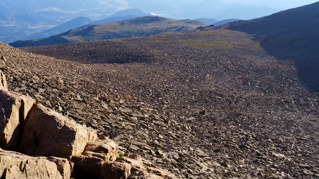
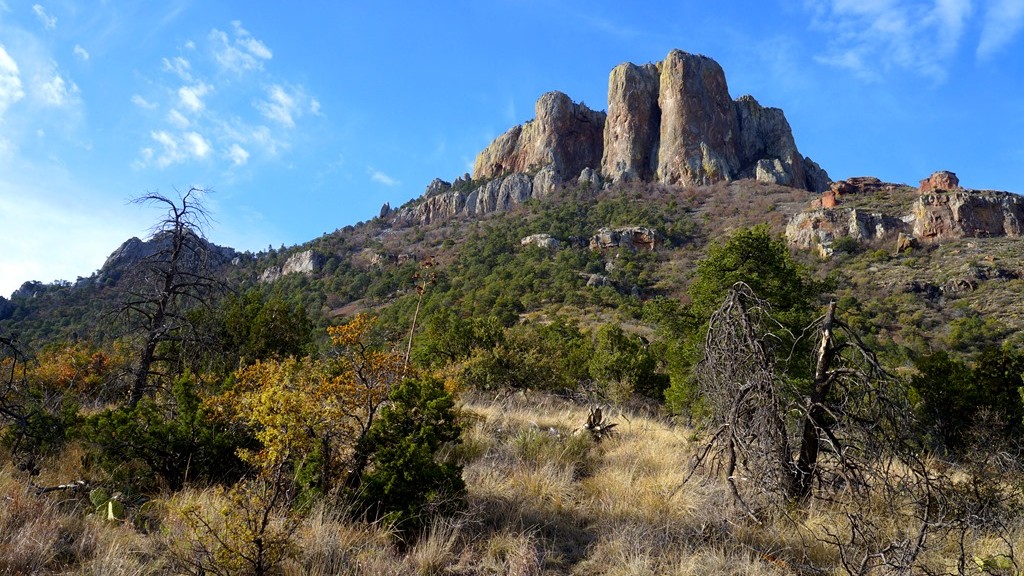
Now at the Boulder Field Campsite we were able to take in some of the surroundings, enjoy a little camaraderie with other hikers attempting to do the same thing, and use toilets in preparation for the next portion of our morning hike. (To catch up with our journey thus far click here to read the previous story.) It was noticeable how much colder the air was here. Even though we were almost the same elevation as the top of Flattop Mountain it seemed much colder to the point of being able to see our breath from time to time. Fortunately the sun was quickly warming us up. While studying the boulder field it became obvious that these boulders filled in the keyhole and more at one time. What natural event occurred causing this part of the mountain to crumble forcing all these large pieces of rock to fall making a river of boulders and leaving this keyhole? Was it ice, an earthquake, or something else?

Looking up at the boulders to be climbed to reach the Keyhole

As I scanned around I kept wondering how can the remaining portion of this hike to the summit be all that difficult? It didn’t appear to be all that long distance wise or a great elevation change from the boulder field. Of course elevation is a major factor for those of us not use to it. After 15 minutes or so we decided to continue on towards the Keyhole. There were several other hikers that climbed up ahead of us providing information on the climb we were about to do. Watching from a little distance it appeared they were going up fairly slow and taking their time. I’ve climbed over rocks before and it doesn’t take that long to continue upward.

A marmot coming to be pet with a hiker in the background climbing boulders

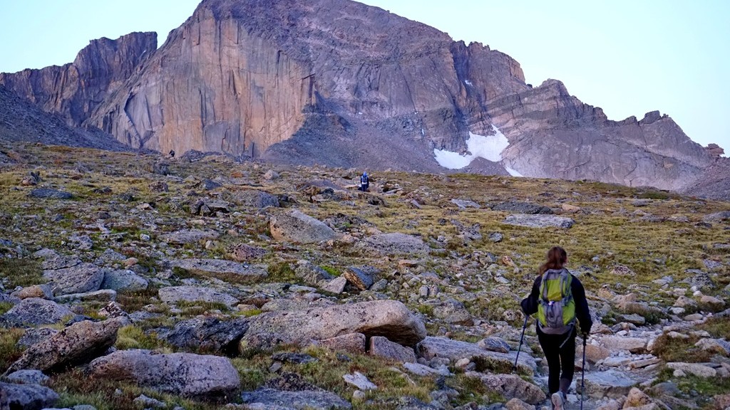
We decided to pack our trekking poles away as they weren’t likely to be much help on the boulder terrain and lifted the packs back onto our backs ready to continue. For this section of the hike on Longs you are basically boulder hopping. Stepping towards the next boulder hoping it’s stable while making your way increasingly higher. At least that’s the plan as it’s easy to just stay at your current altitude and just go sideways if not paying attention. Quickly you begin to realize the altitude makes things increasingly difficult simply because the thinner air causes problems getting enough oxygen to breath normally. It feels like you are running and out of breath after a short time slowing down the pace. Now it makes sense why the hikers ahead of us appeared to go so slowly up into the keyhole. In addition, the higher you go the larger the boulders get and the steeper the incline gets. Looking at the photo above you see a marmot that seemed to want to get pet. In the background is a good comparison of the boulder size next to a hiker.

Exploring the vaille

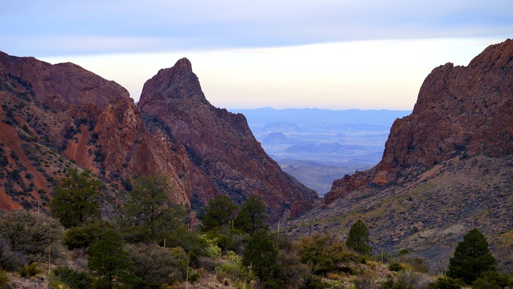
Getting closer to the keyhole we reached the Agnes Wolcott Vaille built as a place of protection from storms for those attempting to reach the top of Longs Peak. Finally almost there! A few minutes exploring this shelter and it was to the keyhole to view out over the Rocky Mountains. We’ve reached the main goal of this adventure – the Keyhole!

One of the views from the other side of the keyhole

Many hikers ahead of us proclaimed the amazing views while perched among the slim layer of rocks forming this keyhole continuing to encourage those below to reach it. They were right about the incredible views sitting in this unique rock formation. From both sides of the keyhole the landscape humbled us with its beauty and vastness. We felt so small among these huge boulders forming large mountains. It seemed to take forever to climb from the campground into the keyhole but according to the timestamps on the photos taken it only took us about 20 minutes or so to complete. While sitting in the keyhole eating a Clifbar and drinking more water we examined the next portion of trail that would take us to the summit of Longs Peak if we felt up to the challenge. I think the expression on Lysa’s face in the picture below gives a good idea of our thoughts!

Sitting in the Keyhole studying the next portion of the trail


Climbing Longs–Getting There

Our journey towards Longs Peak began at 2:30 am. That’s 2:30 am at the trailhead! We were not the first ones there at this time of day as this is a relatively busy trail in the summer but you must start early because it is a long and challenging trail with rain/snow/thunderstorms possible during the afternoon. We began the trail half asleep and unsure of what lay ahead but there were several others here in the same situation so up we we go. Surprisingly it was quite warm at almost 60 degrees F at the start of the trail. I was expecting temperatures in the 40’s during this time of night so off came the jacket before even starting as 60 degrees F is very warm for this strenuous of hiking.

Getting ready to hike to Longs

The entire trail to the summit of Longs Peak using the Keyhole Route is about 7.5 miles long each way with most of that trail needed just to get to the Keyhole. This takes you from the trailhead, up through the trees before reaching the alpine environment above the tree line, and around Mount Lady Washington. Hiking this distance on easier terrain is not terribly difficult for me and I’ve been preparing for this for several months, as you can read here, however this is continually hiking up, often time over steps, rocks, and tree roots, at a fairly steep incline. Even at that, the hiking was not as challenging as I expected which was a nice surprise. The difficulty came with the altitude. Above 10,000 feet, breathing becomes more difficult for me slowing down the pace in order to get adequate oxygen to continue on.

Longs_Peak_map

As we reached the tree line and began hiking in the tundra we got our first view of Longs Peak from closer up. It was a beautiful moonlit morning with the full moon hovering just above the mountain giving us a perfect outline of where we were headed.

Hopefully this is making sense because there are thunderstorms with a lot of lightning as I’m writing this causing distractions.

We took a few minutes to rest and enjoy the surroundings. It was fun to see all of the little lights bobbing along the trail both ahead of us and behind us. Like a little hiker road. While taking this photo the camera low battery symbol began to flash and I realized I forgot extra batteries for this camera and didn’t charge the batteries for the GoPro so taking a lot of pictures was out. This bummed me out because when am I likely to be here doing this again? After coming to terms with my lack of picture taking ability we moved on around Mount Lady Washington.

The first view of Longs Peak with a full moon just above

Almost around Mount Lady Washington and to the boulder field, the sun began to cress the horizon giving us an amazing sunrise way up on the mountain. A sight I hoped to see since preparing for this hike. It took my breath away! Maybe that was just the altitude while hiking. At this point people had created a relatively smooth trail placing stones together to create a sort of sidewalk making it more of a walk than a hike for a little distance. What a nice reprieve from steps and stones! Thank you to whomever did this.

With the sun rising we got our first good look at the mountain we were aiming to climb which is the main photo above. Surprisingly it didn’t look as insurmountable from here as it did from Flattop Mountain and other areas around Rocky Mountain National Park. We’ll see if that stays the case once we get there. Off towards the right I could see the Keyhole which has been the first goal of this hike. Anything after that would be a bonus. A short time later we arrived at the Boulder Field Campground and took a much needed rest before climbing up into the Keyhole. Yes, there really is a campground up here.

It took us about 5 hours to reach the campground and we traveled about 6 miles to this point. Feeling the strenuous hike it felt nice to sit for a little while and take in the views while mentally preparing for the next part. In my research it was said that this is the easy part of climbing Longs Peak. It didn’t seem all that easy to me! What are we in for next? To be continued…..

Sunrise on the mountain


Scott’s Bluff

Sounds like a high stakes card game doesn’t it. In this case it’s Scotts Bluff National Monument named after Hiram Scott who died here. While driving through the plains and fields of Nebraska for a significant time the landscape begins to become a little monotonous making any change stand out. In the panhandle of Nebraska lies these beautiful white bluffs. Kind of an entrance to the mountainous terrain of the Rocky Mountains.

The bluffs at Scotts Bluff National Monument

Our family was on our way to Colorado to explore these mountains and stopped near Scotts Bluff National Monument for the night so decided to learn more about the significance of this national park. It was a beautiful sunny Midwestern late afternoon with temperatures hovering around 90 degrees Fahrenheit and a gentle breeze to keep us cool.

There are 3 tunnels through the bluff taking you to the top.

The first stop was in the Visitor’s Center to pay our entrance fee and learn more about the significance of the area. In this place passed several important trails in history including the Oregon Trail, Mormon Trail, California Trail, and a Pony Express route for a short time. While these are all significant pieces in United States history, the Oregon Trail was the portion that intrigued me the most. I don’t know if it’s simply because the first computer game I played was called Oregon Trail on an Apple computer or because of the historical significance of people migrating west on this long and difficult trail.

Sun moving closer to the horizon behind the bluffs

After this educational stop we progressed to the Summit Road leading to beautiful views on top of the bluffs. Once at the top we took about an hour to hike around the top looking at different views which enhanced all that was recently learned in the Visitor’s Center as well as just enjoying the landscape from this vantage point. As we finished taking in the sights on the bluff we decided a trip to check in at our hotel nearby and refresh after a long day of travel was in order along with dinner before returning to walk along the Oregon Trail as sunset engulfed the horizon.

Walking along the wagons of the Oregon Trail

As the air began to cool and the sun relented it’s midday power we returned to find the park shutting down for the day with only the parking lot left open to explore the Oregon Trail. A very humbling experience to walk along these wagons depicting the horse and ox drawn trains of people and all their belongings attempting to find a better life in the west. Difficult to imagine traveling about 20 miles a day and having to obtain food, water, and shelter each night for the many months it took to reach the western destinations. Certainly an evening such as this was one of the easier days to make this trip but these types of nights only lasted a few months. Not long enough to complete their journey.

Sunset over the Prairie

What a beautiful way to end another day along our journey west!


The Lost Mind Trail

This is what we would call the trail but the real name is Lost Mine Trail which is in Big Bend National Park. It’s listed distance is 4.70 miles however my hiking app registered 5.30 miles round trip. The difference could be all the little side trails to see different views we ventured on that all added up to the extra half mile.

Lost Mine Trail map

We drove a short distance to the trailhead and as soon as we emerged from the car we were in awe of the incredible views surrounding us bringing energy and excitement to get on the trail and climb higher to see even more vistas. This was a trail that was most recommended to us and the trailhead views lived up to those recommendations but could the rest of the trail compete with these amazing sights.

The rocky Lost Mine Trail


Fortunately the trail is well traveled making it easier to follow but it’s littered with rocks to step over so as long as you are capable of walking at an incline for several miles while carefully navigated over and around the rocks. Staying on the trail in this climate is very important in preventing severed erosions during heavy rains which can wash out portions of the trail. These ‘shortcuts’ are tempting but not worth the potential damage for those hiking another day.

As the trail climbed up, the views became more impressive

As the trail continued higher and higher the views continued to be impressive making for distracted hiking and slowing down the pace to get to the top although a water break from time to time is a good idea allowing you to stop and view your surroundings. In addition to the desert mountain scenery we were confronted with cactus’s beginning to bloom adding to this great trail experience.Yet another distraction pulling attention away from getting to the top of the mountain.

Cactus's beginning to bloom

At different points along the way we were joined by other critters, mostly birds, looking as though asking how our hike was going and if we were enjoying the trail. Yes we were having fun for the most part. Unfortunately one of our group had inadequate footwear making the stones on the trail feel as though piercing into their feet with each step. If that’s the worst part than it’s a successful hike.

Mexican Jay joining us on the trail

Arriving at the top the trail levels out providing a sense of relief from continually climbing up, up, up towards the sky. Time to sit and taking in the vast mountainous landscape on this bright, sunny morning and join the others doing the same thing. While taking in the views I got the first opportunity of seeing a road runner closer up just before it decided to jump off the ledge and out of sight forever.

A road runner just before it plunged over the edge

The top of the Lost Mine Trail is actually quite large allowing many people to take in this high point without really creating problems moving back and forth among the boulders. There are many different view points to take in all amazing each to their own making this a nice way to spend an hour and possibly even enjoying a picnic surrounded by rocks and boulders rising from the ground. Watching a sunrise or sunset from this location would be breathtaking I’m sure as long as you’re not alone and with flashlights because the hike to get here or leave here would be in darkness. And ohh yah, there are these little things called mountain lions which tend to be more active during these times.

Taking in the views at the top of the Lost Mine Trail

During most of the time on top of this trail I kept looking at this rock which kind of looks like Homer Simpson and wondered how to climb up to the gap under his chin. I just couldn’t find a good path and without ropes it didn’t seem safe to both get there and climb up the rock. After spending some time exploring the area I decided it wasn’t a safe venture so kind of gave up on the idea. What kind of example would that be for the kids?

A little rock climbing along the way

By the way, challenge accepted.

For more stories of Big Bend you can read posts on the Rio Grande and Window Trail


Window Trail

Entering Big Bend National Park

Our Monopoly board brought us to explore Window Trail which lies inside of Big Bend National Park. This is a moderately difficult trail which covers 3.6 miles in total and covers some beautiful scenery along the way. We were fortunate to be there during the spring when many plants were beginning to bloom and the temperatures were ideal for a hike in the desert. Not to cold and not to warm.

Walking through the desert

Along this trail we enjoyed a number of great sights including Yucca’s and cactus in bloom, a couple of white tail deer, colorful birds, and a friendly road runner. This trail follows the bottom of a canyon most of the way where water drains during heavier rainfalls.

Taking a quick break on the trail

About halfway to the end of the trail we decided it was time to explore a place to take a few minutes to relax and take in the great desert mountain scenery. What’s the first thing kids want to do when stopping near rocks? Well climb them of course and this we did as some of the nicest seats were higher up. This is not recommended by the park although we were definitely not the first ones to do this as I found an orange peel in one of the crevices left by a previous climber.

Window Trail through the canyons

Once entering the canyon portion of the hike there were stairs built to make the trail easier to traverse as during other times of the year there can be water flowing through here which is, of course, the way this canyon was created.

The window where the trail ends

At a couple of points along the way we wondered if we were at the end of the trail. I can say definitively now that the end is very obvious because of seeing the window it was named after and it drops off to the desert floor very abruptly. I’m not sure a person would survive a drop from the window.

Rocks smoothed by years of water and debris sanding them down

As you get close to the window the rocks become extremely slippery due to the running water carrying debris which has sanded down the rocks giving them a polished appearance and feel. It was interesting, especially in this dry season, to see how high the water can get in this canyon and how fast it must rush through to wear down the stone underneath.

The end of the trail with a steep drop to the desert floor

Carefully climbing near the end there is just a narrow slot with a large drop-off which is all very slippery requiring some care to get to. It would be interesting to see this area from the other side after a heavy rain. There must be an interesting waterfall for a short time.

A road runner encounter on the trail

During our trek back we encountered this road runner that didn’t seem to care we were there as it walked right next to us on the trail. Other hikers behind us had the same experience. This particular bird must be use to hikers on this trail and understand prey can be found scurrying as hikers pass by making them easier to find. It gave us the opportunity to all see a road runner finally as each time before the birds would be gone before everyone could see them running across roads in front of the car.

The Frozen River

After a day snowmobiling through Northern Wisconsin we (my cousin and I) wanted to take in a waterfall or two coated in fresh snow so off to Gooseberry Falls we drove. That was the last weekend of the season the trails were open for snowmobiling as it worked out. How fortunate for us?! I was expecting the river to be flowing freely surrounded by fresh snow for some very picturesque landscapes. To my surprise the ice was still well intact over much of the river and waterfalls. For a comparison I’ve included a photo of these same waterfalls during the summer.

Surrounded by Ice

I’ve never been to this area during the winter to see what the waterfalls look like iced over so this was interesting to explore in a completely different perspective. Seeing the waterfalls frozen made me wonder what the process looks like during the winter as the ice gets thicker and thicker. I was also surprised how many people were visiting the falls and taking in a beautiful winter day exploring this state park.

Gooseberry Falls in the summer

Most of the visitors were hiking around the falls, which is what we were doing while some were there to photograph the ice covered waterfalls and one individual was climbing up and over the frozen portions of the falls. Taking some time to talk with him, he says this is his winter version of rock climbing, an activity keeping him out and about enjoying life. It was fun to watch as he picked through the ice with axes and cleats.

Climbing the ice walls

While hiking through the state park I discovered trails in locations I wasn’t aware of trails before. I’ve been to this state park a number of times and never discovered a trail on the opposite side of these waterfalls on top of the cliff overlooking this gorgeous landscape. The views from this newly discovered trail are well worth the extra distance required to get to them. That’s were many of these pictures were taken from. You can see the different angles between most of the waterfall photos and the summer shot.

Peering inside the layers of ice covering the river.

Because one of my goals for 2016 was to photograph snowflakes, I’ve started to look more closely at some of the details in the ice and snow this year. Especially melting ice and snow. The picture above shows the layers that make up ice covering the river as portions are beginning to melt. Some of the freshly fallen snow was beginning to melt and gliding down the ice creating interesting trickles across the several inches of ice still coating the river.

More layers of melting ice.

As we continued our hike around a portion of the Gooseberry River I found a few other locations providing a snapshot into the layer upon frozen layer of water making up this thick sheet of ice. In the above photograph you can see the layers underneath the top layer which is still coated in snow. The darkest portions are running water flowing underneath all of this ice. I believe the water depth in this area is several feet so while it looks relatively shallow, that look is deceiving.

Waterfalls frozen in place

Making our way to the lower falls you can see the magnificent rocks covered in all of this ice. in our explorations we confirmed water running under much of this as there were a few spots open to the water underneath as well as sounds of rushing water muffled by layers of ice. There were some great shapes created from the freezing and thawing during the recent days. It’s interesting to look at all these little details that combine together to make this amazing ice walls. Sometimes I forgot I was standing over running water as I was attempting to photograph these small icicles and crystals and their curious shapes.

One of the many icicles making up this huge ice wall.

Darkness was approaching on this already cloud covered light and the wind was growing colder so it was time to exit this beautiful ice river and falls. Before we did I was amazed further by the resilience of trees that grow out of these rock ledges as in the winter they are also ice covered. How they continue to grow surprises me and I work with plants almost every day. These tree roots and icicles clinging to the side of this stone wall made for a sight you don’t expect to see.

Tree roots growing through ice and rock

Gooseberry Falls State Park has a beautiful visitors center with great information about the North Shore of Minnesota but was unfortunately closed as we were exiting. In the absence of park personnel, we were sent on our way by some of the park residents. Although they seemed to prefer our departure instead of wanting to be interacted with.

Local resident deer sending us on our way

Houston, We Have a Problem

The problem was our time here was too short. We were in Houston for a couple of days before boarding a cruise ship to the Caribbean and were looking for something interesting to explore. Researching things to do in Houston, NASA was at the top of the list and reading different people’s experience here we decided that’s how we wanted to spend one of the days.

Exploring the Moon

General admission gains access to a days worth of exhibits which include different space capsules, informational movies, multiple types of space trainers, equipment used on different space travels, and even a lab situation where moon rocks were examined all put into settings made to give you a good idea of what it’s like going into space. In addition, you can visit Independence Plaza which holds a shuttle carrier holding a shuttle, Rocket Park were there are several different rockets used to travel into space, as well as a couple of other buildings showcasing some of NASA’s current work via a tram.

Experimenting with Moon rocks

We were in Houston visiting Johnson Space Center and this could be our only chance to experience this with our children so we decided we wanted to take in the full experience and went on the VIP tour. With this tour you get to visit areas not available to any other tour such as the underwater training center as well as get up close and personal in some of the areas were the tram does go such as historic mission control and building 9 where you can view new technology that may be used in future space endeavors along with lunch which can be a little expensive at a place like this.

Skylab Space Station Trainer

Our first stop was the underwater training facility. Here they have a life-size International Space Station for astronauts from around the world to train on. Luckily for us, there were a couple of astronauts training so we could see how they prepared to work in space. It’s very interesting because while underwater they each have at least two assistants for training and safety. This pool is massive as you might imagine to hold a replica of the Space Station. With space suits on these astronauts can’t get themselves into or out of the pool so they have a small crane to get them in and out.

Underwater training pool

Next we explored building 9 and got to see many of the new creations meant for use on the moon and beyond such as advanced rovers and other exploration vehicles. There were different types of space suits on display, Robonauts which can be used to explore areas not as hospitable to people, and the Orion capsule being built for possible missions back to the moon. Surprisingly, this Orion Capsule has much the same design as capsules already used to go to the moon. The technology to operate them, however, is much better and so is the equipment that can be used to explore more of the moon. Also in Building 9 there is a Soyuz capsule currently used to transport astronauts to the International Space Station and parts of the space station for these capsules to connect to. Seeing these in person is really interesting.

NASA's nxt Lunar rover

Something we got to experience, that very few get to be a part of, was the launch of astronaut Scott Kelly live. While his launch took place in Kazakhstan, the people at Johnson Space Center prepared an area for their VIP tour guests to view the launch. Because of this launch our trip to see the new Mission Control needed to be delayed as a number of NASA officials were in Mission Control as this trip began. Our experience watching this brought the United States involvement in the International Space Station to life more than any news story could. This post was not intended to coordinate with his return almost a year later. That is just a lucky coincidence as I had planned on this post a week or so before realizing Scott Kelly was returning home from his year at the space station.

Watching Scott Kelly's launch at NASA

After watching the launch to the International Space Station, our tour continued on to Rocket Park where there are several different rockets used to propel people into space. The highlight of Rocket Park is the Saturn V rocket which was used to take people to the moon. In the photograph above you can see a person walking under the rocket on the far side to indicate just how massive this rocket really is. You could stand inside one of the rocket engines and there are five engines that powered this rocket from the Earth. Walking around Rocket Park you can start to put together the timeline from the first rockets to Saturn V and even see the equipment that went into making the shuttles. Most of this rocket was used to get it off the ground and to the moon. Very little was needed for the return trip.

Saturn V

On to Mission Control. Here we were able to sit at the actual desks used to control these missions to the moon and some of the earliest Space Shuttle flights. It really felt like going back in time and humbling to be in this amazing and historic control center. There was a few minutes of presentations by NASA officials and then we had some time to look around this piece of American history. How much better could our experience get?

NASA's old Mission Control

How about witnessing the new Mission Control as they maneuver the International Space Station for the docking of the Soyuz Capsule with Scott Kelly aboard? Here I learned information I was unaware of before such as NASA is the organization that actually flies the space station and a trip from Earth to the International Space Station takes mere hours. I always imagined a trip of this distance would take a day or more. One other surprise to me was how ordinary a launch appears in Mission Control. Not all the desks were filled and people appeared to just be doing their everyday business and having conversations with colleagues just as many of us do only they’re in control of vehicles thousands of miles away and responsible for the lives of those aboard. I’ve seen more chaos in a grocery store. This was the end of our day at Johnson Space Center which required relaxing by the pool of our hotel the rest of the night just to absorb all of the information and experiences from this day. The night sky has a little different appearance now.

NASA's new mission control

Fireflies in the Smoky Mountains

While exploring Great Smoky Mountain National Park we came across a brochure explaining the synchronous fireflies. Fireflies are visible  in many areas and we’ve enjoyed and evening or two watching these interesting little insects near our home. I’ve even taken some time to try and photograph their nighttime dances with some success. It was decided that a trip to Elkmont, which is the best location for viewing this nightly light show in June, that night would be an enjoyable way to end a great day in the Smokies.

A Dobson Fly also waiting to see the light show.

According to the brochure, the peak days were already behind us but that there were great light shows for several weeks still to be seen. As we arrived in the Elkmont area our first challenge was to find a spot to park which proved more difficult than expected as we were there a couple of hours before nightfall. Apparently we weren’t the only ones wanted to witness these synchronous fireflies. Eventually we followed others and parked alongside the road and walked back to the viewing area which was being descended on by hundreds of other people. This must be a good show if there are this many people here this early in the evening.

Little River in Elkmont

As darkness began to fall over the area we wondered into the forest next to Little River and found what appeared to be a nice relaxing spot to lose ourselves in the increasing darkness along with others hoping to witness a firefly spectacle. While waiting for these insects to begin their show we explored the river’s edge until a flash caught our attention back in the woods. And then another, and another. The show was beginning! As the minutes went by there was some firefly flashing but nothing more spectacular than we would see near home. After about 20 minutes we decided it was time to retire for the evening as it was a long and eventful day leaving us ready for our pillows.

A single firefly lighting up the night

On our way out of the forest we stopped to talk with another couple who lived in the area. During the conversation they explained that the show had not really started yet and we should stay awhile longer. Soon after there were golden streams of light blinking all over. It was beautiful and exciting to watch. They were all over the place showing off their tricks of flight and color. Now it makes sense what all the publicity was about. We couldn’t imaging what the show would be like during the peak season. Now this was about as perfect as it could be to end a day full of adventures.

The show is getting better

And better

This is definitely worth seeing

Waterfalls at Tettegouche

High Falls on the Baptism River

While hosting a student from France this summer we took a couple of days to head to the North Shore of Minnesota to see Lake Superior. A great place to stop is Tettegouche State Park to see both Lake Superior and the highest waterfalls entirely in Minnesota (there’s one slightly taller but it borders Minnesota and Canada). This was in the middle of August so the waterfalls are not gushing with as much ferociousness as earlier in the year but still a beautiful sight. It was raining and nearing nightfall during our time here which actually allowed us to have these falls all to ourselves. A rare opportunity this time of year.

Jumping into the Baptism River at High Falls

The Baptism River is cold (yet warm when compared to Lake Superior) people like to swim near the falls and jump from a nearby cliff. A dry towel to wipe the water from your skin and warm clothing to put on shortly after was a good idea on this day as the temperature was not very warm and there was no sun to warm up in so hypothermia was certainly a possibility. If you’re ever in the area I highly recommend a stop at Tettegouche State Park to explore the high falls. There is a short hike of just under a mile to get there from the nearest parking lot which is worth it if you can make it. There are a couple of smaller waterfalls to see if you have the time to hike to them. Darkness was approaching so we were unable to check out the rest of the smaller waterfalls. That will have to wait for another time.

Up the River to The High Falls

Vacation Style

Going to the Ocean on Vacation

What’s your vacation style? No, not vacation in style. How do you like to spend your time away on vacation. Just a quick internet search brought some entertaining results which centered around luggage styles and travel fashion. I’ve gone through three different styles as I’ve gotten older and my choice of vacations is an indication of that. They are: Beach Bum, Whatever Happens, and Adventurer.

The first vacations I had decisions in was crossed between ‘beach bum’ and ‘whatever happens’. Spring Break in Daytona Beach is what I consider my first independent vacation where I primarily just wanted to lounge on the beach with the biggest decision to be made for the day was what to eat. A second vacation on a cruise ship brought more of the same as I never wanted to leave the ship even while at port. Apparently there is enough adventure when you’re a college student between classes, homework, working, and activities that vacation was all about R & R. Of course, spring break usually came after difficult exams and large projects requiring a mental vacation.

Beach Bum

That first vacation along with several after did include a bit of ‘whatever happens’ as Daytona Beach was the sight of Mtv’s Spring Break broadcasts and I took part in those from time to time along with a quick trip for my first time to Disney World. Planning is not a priority for these types of vacations but you still decide to take advantage of an opportunity or two when they happen to go on an adventure. Maybe a snorkeling trip or a ride in a submarine for something to talk about later.

Currently I reside in the adventure vacation style which can take quite a bit of planning. As daily life now involves a lot of routine, vacations need to be more fulfilling to me. The need to just catch some sun has passed and actually feels like wasted time away from work. It usually takes 3 – 4 days away to begin to mentally get a break from the grind of everyday events so just using my vacation time a day at a time does not accomplish its purpose of refreshing me. My goal often times is to return from a trip needing to catch up on sleep but with many great memories packed into a short time.

Adventurer

There are definitely downsides to the ‘adventurer’ vacation style. Usually these trips can be more expensive because everything costs money and they require more time planning and making reservations. Along with the planning can often come additional stress because of trying to figure out if you’ve taken care of everything in preparation and needing to be at a certain place by a certain time once on vacation.

These vacation styles kind of came to me recently because of our next trip coming this spring break which happens to be a Caribbean Cruise. Cruising has lost its appeal to me because I want to spend the time in port doing things instead of be on a ship most of the time with all that food. So why am I going on a cruise you ask? It’s has become part of a family trip to celebrate my mother and father in-laws 50th anniversary and they would like that trip to be on a cruise ship. Our initial plans where to visit Padre Island and Hot Springs Arkansas for spring break which falls into the ‘Adventurer’ category. That will happen another time as a 50th wedding anniversary is an incredible milestone to me. I can only try to imagine it.

Going on a Cruise Ship

Back to my vacation style realization. When booking this next trip the portion I really was having a difficult time with is spending all that time on the ship. That has become kind of boring to me and I’m not all that attached to food so there is not as big of an appeal there either. That enlightenment helped me understand that I’m no longer a ‘beach bum’ and have moved further from the ‘whatever happens’ style as well. For this trip being in the ‘whatever happens’ category would be most beneficial but I’m not able to let myself and my family be that type of traveler because I know I’m missing an opportunity to create life long memories with my wife and children and the chances to do that are diminishing as the children get older.

It’s interesting to me to recognize changes in how I spend my vacation time from when I first started taking vacations to now. I’m sure that will continue to change as things in life continue to evolve. I know several people who like to be in the ‘beach bum’ or ‘whatever happens’ categories and that is a great place to be, just not for me at this point in my life. Is there a benefit to classifying vacation styles? Probably not. Just something I did without realizing it and decided to put out there. Enjoy you’re vacation any way you can!

Creating Family Memories