Category Archives: Adventure

Scott’s Bluff

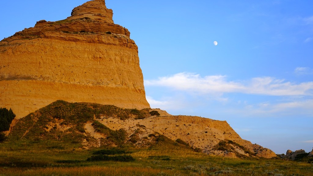
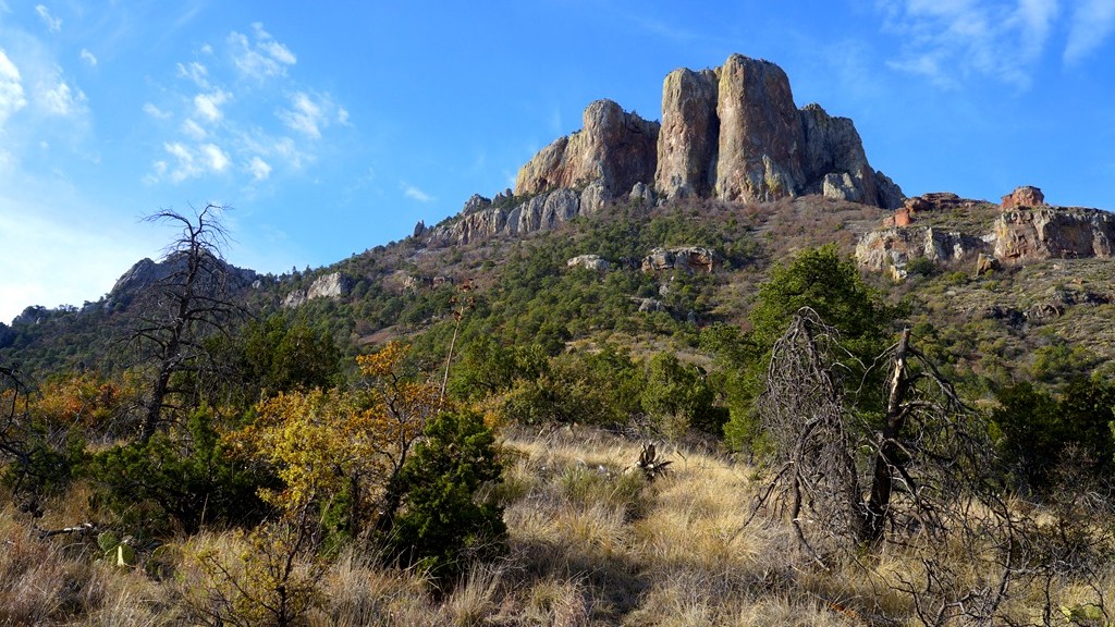
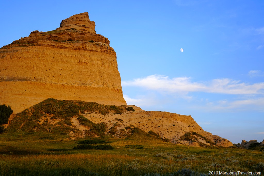
Sounds like a high stakes card game doesn’t it. In this case it’s Scotts Bluff National Monument named after Hiram Scott who died here. While driving through the plains and fields of Nebraska for a significant time the landscape begins to become a little monotonous making any change stand out. In the panhandle of Nebraska lies these beautiful white bluffs. Kind of an entrance to the mountainous terrain of the Rocky Mountains.

The bluffs at Scotts Bluff National Monument

Our family was on our way to Colorado to explore these mountains and stopped near Scotts Bluff National Monument for the night so decided to learn more about the significance of this national park. It was a beautiful sunny Midwestern late afternoon with temperatures hovering around 90 degrees Fahrenheit and a gentle breeze to keep us cool.

There are 3 tunnels through the bluff taking you to the top.

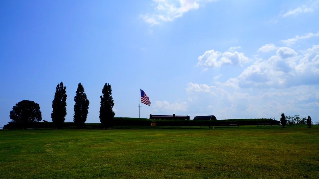
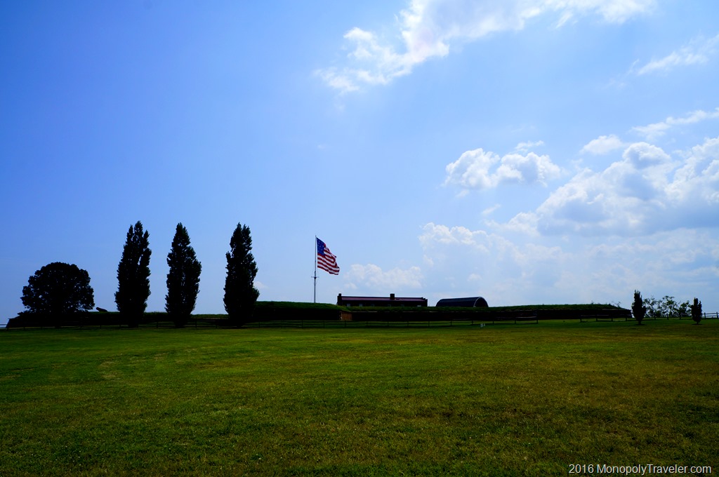
The first stop was in the Visitor’s Center to pay our entrance fee and learn more about the significance of the area. In this place passed several important trails in history including the Oregon Trail, Mormon Trail, California Trail, and a Pony Express route for a short time. While these are all significant pieces in United States history, the Oregon Trail was the portion that intrigued me the most. I don’t know if it’s simply because the first computer game I played was called Oregon Trail on an Apple computer or because of the historical significance of people migrating west on this long and difficult trail.

Sun moving closer to the horizon behind the bluffs

After this educational stop we progressed to the Summit Road leading to beautiful views on top of the bluffs. Once at the top we took about an hour to hike around the top looking at different views which enhanced all that was recently learned in the Visitor’s Center as well as just enjoying the landscape from this vantage point. As we finished taking in the sights on the bluff we decided a trip to check in at our hotel nearby and refresh after a long day of travel was in order along with dinner before returning to walk along the Oregon Trail as sunset engulfed the horizon.

Walking along the wagons of the Oregon Trail

As the air began to cool and the sun relented it’s midday power we returned to find the park shutting down for the day with only the parking lot left open to explore the Oregon Trail. A very humbling experience to walk along these wagons depicting the horse and ox drawn trains of people and all their belongings attempting to find a better life in the west. Difficult to imagine traveling about 20 miles a day and having to obtain food, water, and shelter each night for the many months it took to reach the western destinations. Certainly an evening such as this was one of the easier days to make this trip but these types of nights only lasted a few months. Not long enough to complete their journey.

Sunset over the Prairie

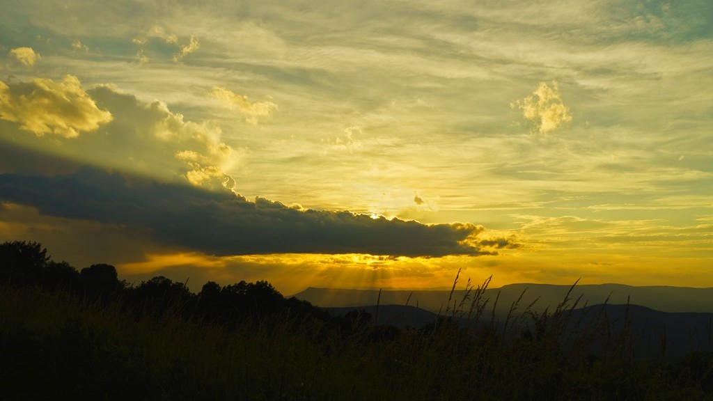
What a beautiful way to end another day along our journey west!


Preparing for a Rocky Mountain Hike

Since exploring Rocky Mountain National Park in 2009 I’ve wanted to return as it is such a beautiful place. Our last trip was to hike to Flattop Mountain Trail which is the location on our National Parks Monopoly Board. In 2009 we made it to the sign and returned to the car. I’ve always felt that I would like to hike the trail in its entirety someday.

Flattop Mountain Trail

That someday will happen this summer. Or at least we are going to be back in the park and hopefully the weather cooperates allowing me to hike to the top of Flattop Mountain which is a 10 mile hike round trip. Typically 10 miles isn’t a concern for me but it gets a little more difficult with the incline/decline and altitude in a mountain setting. Flattop peaks at just over 12,000 feet altitude and while this has an impact on me it wasn’t very bad the last time I was at this height.

Look at the beautiful surroundings

In addition to Flattop Mountain I’ve added in the challenge of hiking to the top of Long’s Peak which is a 15 mile trip and tops out just over 14,000 feet in altitude. A few years ago I would have never considered doing this as I’m not in physical condition to do so. After reading a few long distance hiker’s blog I began to consider it and figure out what it would take for me to do.  The idea of hiking to the top of the tallest peak in Rocky Mountain National Park, which I’ve looked at from an airplane, and see it from the other direction is a challenge I want to take on.

In order to be successful at these hikes I’ve been in training since January to build my legs and also try and increase my lung capacity as much as possible to prepare for the thinner air at higher altitudes. This training has included hiking several miles at a time carrying a 45 pound training pack which is at least double the weight of what my actual backpack will be. Hopefully the actual pack will feel quite a bit lighter so I don’t mind carrying it for a much longer distance. The training pack also put a heavier load on my legs building those muscles a bit more.

One of my practice hiking trails

Additionally I’ve been working with inline skates and biking with the occasional walking up and down stairs for 45 – 60 minutes with a loaded backpack on. Some days have been more challenging than other to go work out just like it is for anybody. In January I would go out on the trail even at temperatures of –12 degrees F and in the summer heat and humidity when I would return home so full of sweat I looked as though I had jumped into a lake. During these time I just needed to think about climbing mountain trails and my motivation would quickly return and I could walk faster or pedal harder forgetting about the conditions I was training in.

Biking on the trail

The time has come to see if all of that training will pay off in the form of an easier and successful hike. Certainly some of the mountain trails, especially near the top of Long’s Peak, have been a little intimidating but I’ve seen enough video and photos of the trail and have enough confidence in my abilities that as long as the weather remains favorable I’ll make it to the top.  If the weather does not cooperate than the risk does not become worth the reward of summiting Long’s Peak and I will turn around which is why the planned start time is around 2:30am to increase the odds of completing my goals. It’ll be fun either way I’m sure as there is nothing but amazing scenery all around.


Mystery Cave

A few years ago I searched for caves of Minnesota, after exploring Mammoth Cave in Kentucky, and found Mystery Cave. This is a state park which offers tours through the largest caverns of the cave located in the bluffs of Southeastern Minnesota. We’ve attempted to plan a visit when we first discovered it but plans fell through so we kept it on a list of “someday” things to do. Fortunately this “someday” event actually was achieved this summer. We hosted a French student for a few weeks and thought this would be an enjoyable place to show some of the many faces of Minnesota. He had never been in a cave before and was fascinated with it.

Walking through the caverns carved by water

Caves are very fascinating places and this one was no different. As is common, it is cool in Mystery Cave which felt nice on a hot summer afternoon. After descending a couple of flights of stairs we were transported into another world. Here is complete darkness surrounded by layers and layers of stone carved over thousands of years of water carrying away each piece it can grab until it can no longer flow through this area. These natural tunnels continue to transform yet today as water from the surface still drips through these rocks altering their environment.

Veins of Mystery Cave

As this water drips down the stone walls it carries with it minerals from above which separate from the water as it flows down these walls creating these veins throughout the caves giving them an appearance of life. The veins of Mystery Cave give it a beautiful and amazing ambiance adding to the wonder around each new cavern. What will this cave look like in a thousand years from now? What will be the same, if anything? What did the cave look like a thousand years ago?

An underground lake

This is the first cave I’ve toured that I saw an underground lake. While it was smaller than I was prepared for it was incredibly clear and had a very deceptive depth that could only be realized by shining light through the surface and moving it around. Even then the deception required a focused realization and understanding of what you are viewing.  We continued through some of the narrow passageways returning to the beginning and climbed out to natural daylight squinting while adjusting to it once again. It was cool enough inside and hot and humid enough outside that everyone’s glasses fogged immediately upon exiting the cave making those with corrective lenses laugh as this usually happens during the winter, not summer.

_DSC9150


The Lost Mind Trail

This is what we would call the trail but the real name is Lost Mine Trail which is in Big Bend National Park. It’s listed distance is 4.70 miles however my hiking app registered 5.30 miles round trip. The difference could be all the little side trails to see different views we ventured on that all added up to the extra half mile.

Lost Mine Trail map

We drove a short distance to the trailhead and as soon as we emerged from the car we were in awe of the incredible views surrounding us bringing energy and excitement to get on the trail and climb higher to see even more vistas. This was a trail that was most recommended to us and the trailhead views lived up to those recommendations but could the rest of the trail compete with these amazing sights.

The rocky Lost Mine Trail


Fortunately the trail is well traveled making it easier to follow but it’s littered with rocks to step over so as long as you are capable of walking at an incline for several miles while carefully navigated over and around the rocks. Staying on the trail in this climate is very important in preventing severed erosions during heavy rains which can wash out portions of the trail. These ‘shortcuts’ are tempting but not worth the potential damage for those hiking another day.

As the trail climbed up, the views became more impressive

As the trail continued higher and higher the views continued to be impressive making for distracted hiking and slowing down the pace to get to the top although a water break from time to time is a good idea allowing you to stop and view your surroundings. In addition to the desert mountain scenery we were confronted with cactus’s beginning to bloom adding to this great trail experience.Yet another distraction pulling attention away from getting to the top of the mountain.

Cactus's beginning to bloom

At different points along the way we were joined by other critters, mostly birds, looking as though asking how our hike was going and if we were enjoying the trail. Yes we were having fun for the most part. Unfortunately one of our group had inadequate footwear making the stones on the trail feel as though piercing into their feet with each step. If that’s the worst part than it’s a successful hike.

Mexican Jay joining us on the trail

Arriving at the top the trail levels out providing a sense of relief from continually climbing up, up, up towards the sky. Time to sit and taking in the vast mountainous landscape on this bright, sunny morning and join the others doing the same thing. While taking in the views I got the first opportunity of seeing a road runner closer up just before it decided to jump off the ledge and out of sight forever.

A road runner just before it plunged over the edge

The top of the Lost Mine Trail is actually quite large allowing many people to take in this high point without really creating problems moving back and forth among the boulders. There are many different view points to take in all amazing each to their own making this a nice way to spend an hour and possibly even enjoying a picnic surrounded by rocks and boulders rising from the ground. Watching a sunrise or sunset from this location would be breathtaking I’m sure as long as you’re not alone and with flashlights because the hike to get here or leave here would be in darkness. And ohh yah, there are these little things called mountain lions which tend to be more active during these times.

Taking in the views at the top of the Lost Mine Trail

During most of the time on top of this trail I kept looking at this rock which kind of looks like Homer Simpson and wondered how to climb up to the gap under his chin. I just couldn’t find a good path and without ropes it didn’t seem safe to both get there and climb up the rock. After spending some time exploring the area I decided it wasn’t a safe venture so kind of gave up on the idea. What kind of example would that be for the kids?

A little rock climbing along the way

By the way, challenge accepted.

For more stories of Big Bend you can read posts on the Rio Grande and Window Trail


The U. S. National Anthem

Every time I hear the United States National Anthem, there is a deeper meaning after visiting the place it was written – Fort McHenry in Baltimore, Maryland. One of the first things you can see upon nearing the fort is the tall flagpole carrying a huge American flag which author Francis Scott Keys was looking for during the bombing of the fort by British soldiers.

Canons protecting the fort

Once inside the fort, you can see where the canons that defended this fort during the attack were placed. This brings the attack to life imagining soldiers maneuvering cannons and loading them to fire back at British ships in Chesapeake Bay outside of the fort while taking cover as these ships fired back.

Looking out into Chesapeak Bay where the National Anthem was first written

Walking along the top of the fort walls, Chesapeake Bay is clearly visible shining in the bright blue, sunlit sky. After seeing the fort and many of its canons you begin to visualize British ships in the water firing almost causing you to quickly duck back behind the brick walls for protections.

Watching the flag flying in the wind high over Fort McHenry

It’s very humbling to think of this large icon of America, its flag, flying in the wind while soldiers engaged in heavy battle firing at each other through a smoke filled sky created from canon fire. To imagine what this must have looked like to Francis Scott Keys and the impact it had on him during these days. His surprise, joy, and pride to see Fort McHenry and the United States flag continuing to exist in all their glory once the battle ceased. On this Independence Day I have further respect for those who have given much to give us our freedom and continue to defend it yet today!

A huge American flag flying in the courtyard


Young Bald Eagles

I’ve been fortunate this year to watch bald eagles as they maintained their nest and are currently raising young eaglets. I don’t visit frequently as I prefer to allow them to continue without being disturbed too frequently risking their departure earlier than they should. I’ve only been close enough to see the nest a couple of times.

Stretching their wings

The first was in March before there were any leaves on the trees making it easier to find. They could also see me easily and were not happy about me being in their territory. It was at that time that I learned exactly what bald eagles sound like and have been able to identify their calls since. There have been several times I’ve been in the area and heard their calls telling me they’re still occupying the nest and raising the young without going near the nest. Being able to recognize their calls have directed me to other nests now that I know what I’m listening and looking for.

Being Spotted

My second visit to their nest was later in the spring after all of the trees grew leaves hiding the nest from most spots on the ground. Fortunately I found an area to observe and photograph the eagles for a short time. During that time the adults fed their eaglets and the young eagles danced around the nest before and after eating.

While photographing I didn’t realize that one of the adults was searching for the sounds my camera was making until it was looking directly at me. Once spotted the eagle began screeching and flew a short distance away while the eaglets hid inside their huge nest built from large sticks.

A little while later the young eagles began peering over the sides at me again and I decided it was time to leave them so they could continue on with life. Soon I expect they will be flying and difficult to find near the nest but it was fun and educational to watch them for a few hours.

Unhappy adult Bald Eagle


Petroglyph

Excited to begin our Spring Break adventures, we landed in Albuquerque, New Mexico on a warm spring like day in mid March headed to Petroglyph National Monument. This National Park is a smaller park in Albuquerque established to preserve the rock drawings created hundreds of years ago. This was our second Monopoly board excursion with much to see and learn.

Walking through Petroglyph National Monuments enjoying the snow capped mountains behind

Petroglyph has a number of short hiking trails which bring you near many of the drawings carved into volcanic rock by people living in this area long, long ago and a modest visitors center to provide more information of this area and its formation. We took in a few of these hikes while enjoying the warmth on this bright, sunny afternoon with mountains lining the horizon. A great day to be here, especially since when I returned a week later it was to snow and ice blanketing many parts of this area.

Studying on of the petroglyphs

Most of the hikes wonder around and through rocks and what must younger people do when approaching rocks? Well they must be climbed of course. Before allowing them to touch a rock we tried to find any petroglyphs so they would risk damage even though these rock drawings have been there for hundreds of years and likely have been climbed over numerous times before.

If there are rocks around, they must be climbed

While hiking we would come upon a petroglyph which was interesting but it seemed like a bunch of kids were let loose in the park with sticks or rocks and told to draw on the rocks. How did we know if the drawings were 5 days old or 500 years? It was hard to know in most cases so we had to just believe these have been there for a long time. We were amazed at how well preserved they were given how long many have been here although I’m very poor at analyzing them to figure out what they may be showing so well preserved or not, I couldn’t really decide what they were portraying. Most of the petroglyphs were simple shapes to depict and animal, bird, or person with some being more intricate to show a particular type of person or event. Seeing these rock drawings in person provided some great historical education to think back on when traveling to different places.

Climbing Around in Shenandoah

After a long day on the road that started in Knoxville, Tennessee, we ade it to Shenandoah National Park in time to view a great sunset. The next day was for exploring the park. Driving along Blue Ridge Parkway we came upon a trailhead and stopped to see where the trail lead. It was Bearfence trail leading to Bearfence Overlook, a nice 1 mile hike to start out on.

Climbing up Bearfence trail

There are two options to hike on Bearfence. First, you can take the Appalachian Trail for most of the way to the overlook and then cut up on Bearfence Trail to arrive at a beautiful mountain view or you can take Bearfence Trail most of the way climbing up and over sharp rocks for a good portion of the mile. Which one would you take? The rock scramble route it is.

The Rock Scramble

The trail starts out on a portion of the Appalachian Trail but quickly begins climbing up into the mountainous rocks of Shenandoah. Some of these areas are fairly steep and go over sharp plates angled up towards the sky. Navigating through the trail requires following blue painted markers on the rocks which are fairly easy to find among the different boulders.

Taking a break

As we neared the top we took a few moments to enjoy the views around us before continuing to the Bearfence overlook. On this beautiful sunny morning we could see several valleys and hills covering miles from these gray colored boulders covered in multiple colors of lichens. The wind was blowing strong enough that we had to be a little careful in our steps otherwise we would be moved off of the trail and in the wrong spot that could result in slipping causing an injury.

Plants growing in the rocks

Something that struck me as interesting was the pockets of water tucked amongst these massive rocks making up the mountain and the different types of plants growing out of the rocks. In a single grouping, such as the one in the photo above, you would have moss, ferns and sedum all protected in a crevice. Moss and ferns generally like moist conditions while sedum tend to thrive in dryer situations which is why these plants growing in the same spot seemed odd to me. Does that indicate the different conditions over a year that combine to create a harsh environment? Wet at times and dry in other times?

Nearing the top

Continuing on the trail, we climbed up and around rocks and boulders as we explored all it had to offer forgetting the workout required to get to the top. It was just fun to experience the Appalachians in Shenandoah National Park in this manner. We were never sure where the end was or if we passed it so we just followed a trail and kept on hiking.

Bearfence Lookout

The end became very obvious because there was no more trail on top of a rock with drop offs on three sides. Once again the views were amazing as we looked out over the neighboring hills separated by meandering valleys and trees all around us typical of these mountains. After a short time we worked our way back to the car, off to explore other areas of this National Park.


Rio Grande

While in Big Bend National Park to hike the Window Trail we traveled to see the Rio Grande which separates the United States and Mexico. It seemed somewhat ridicules to be this close to one of the US borders and not take some time to visit it first hand. From a distance there were mountains on the horizon which somewhat matched my expectations of what this area would look like.

The Rio Grande

For whatever reason, whether from photos or things I’ve read, I expected there to be a canyon kind of like the Grand Canyon with a river running through it and on one side would be the United States and the other Mexico. In this particular area that was not really the case. On one side was a desert, relatively flat, and the other was a tall cliff separated by the Rio Grande.

Looking north to Big Bend National Park and the Chisos Mountains

Making our way to the Santa Elena Canyon Trail we discovered that the river bends and enters a canyon with sheer cliffs on either side. Maybe this is why my expectations were of a canyon with the Rio Grande running through it. Even so, I was surprised by how steep these canyon walls are and how small the river is. At least how small it was while we were there. During times with higher rain amounts I imagine this river to swell considerably. While learning more about the Rio Grande we found out that one of the issues with it being a major border was that the river can change course over time from a rising and falling river which also can change the border between Mexico and the United States.

Rio Grande inside the canyon

Shortly after exploring the Rio Grande I realized that this completes our adventures from one end of the United States to the other. We’ve been to the Canadian/United States border after hiking in Isle Royale National Park, the United States/Mexico border while in Big Bend and the East Coast and West Coast. Also we explored Alaska/Canadian border. The only piece left is Hawaii which will be our final trip in 2018.

image


Window Trail

Entering Big Bend National Park

Our Monopoly board brought us to explore Window Trail which lies inside of Big Bend National Park. This is a moderately difficult trail which covers 3.6 miles in total and covers some beautiful scenery along the way. We were fortunate to be there during the spring when many plants were beginning to bloom and the temperatures were ideal for a hike in the desert. Not to cold and not to warm.

Walking through the desert

Along this trail we enjoyed a number of great sights including Yucca’s and cactus in bloom, a couple of white tail deer, colorful birds, and a friendly road runner. This trail follows the bottom of a canyon most of the way where water drains during heavier rainfalls.

Taking a quick break on the trail

About halfway to the end of the trail we decided it was time to explore a place to take a few minutes to relax and take in the great desert mountain scenery. What’s the first thing kids want to do when stopping near rocks? Well climb them of course and this we did as some of the nicest seats were higher up. This is not recommended by the park although we were definitely not the first ones to do this as I found an orange peel in one of the crevices left by a previous climber.

Window Trail through the canyons

Once entering the canyon portion of the hike there were stairs built to make the trail easier to traverse as during other times of the year there can be water flowing through here which is, of course, the way this canyon was created.

The window where the trail ends

At a couple of points along the way we wondered if we were at the end of the trail. I can say definitively now that the end is very obvious because of seeing the window it was named after and it drops off to the desert floor very abruptly. I’m not sure a person would survive a drop from the window.

Rocks smoothed by years of water and debris sanding them down

As you get close to the window the rocks become extremely slippery due to the running water carrying debris which has sanded down the rocks giving them a polished appearance and feel. It was interesting, especially in this dry season, to see how high the water can get in this canyon and how fast it must rush through to wear down the stone underneath.

The end of the trail with a steep drop to the desert floor

Carefully climbing near the end there is just a narrow slot with a large drop-off which is all very slippery requiring some care to get to. It would be interesting to see this area from the other side after a heavy rain. There must be an interesting waterfall for a short time.

A road runner encounter on the trail

During our trek back we encountered this road runner that didn’t seem to care we were there as it walked right next to us on the trail. Other hikers behind us had the same experience. This particular bird must be use to hikers on this trail and understand prey can be found scurrying as hikers pass by making them easier to find. It gave us the opportunity to all see a road runner finally as each time before the birds would be gone before everyone could see them running across roads in front of the car.